Your gateway to endless inspiration
Crater - Blog Posts

Name the Artemis Moonikin!
Choose your player!
As we gear up for our Artemis I mission to the Moon — the mission that will prepare us to send the first woman and the first person of color to the lunar surface — we have an important task for you (yes, you!). Artemis I will be the first integrated test flight of the Space Launch System (SLS) rocket and the Orion crew capsule. Although there won’t be any humans aboard Orion, there will be a very important crewmember: the Moonikin!
The Moonikin is a manikin, or anatomical human model, that will be used to gather data on the vibrations that human crewmembers will experience during future Artemis missions. But the Moonikin is currently missing something incredibly important — a name!
There are eight names in the running, and each one reflects an important piece of NASA’s past or a reference to the Artemis program:
1. ACE
ACE stands for Artemis Crew Explorer. This is a very practical name, as the Moonikin will be a member of the first official “crew” aboard Artemis I.
The Moonikin will occupy the commander’s seat inside Orion, be equipped with two radiation sensors, and wear a first-generation Orion Crew Survival System suit—a spacesuit astronauts will wear during launch, entry, and other dynamic phases of their missions. The Moonikin will also be accompanied by phantoms, which are manikins without arms or legs: Zohar from the Israel Space Agency and Helga from the German Aerospace Center. Zohar and Helga will be participating in an investigation called the Matroshka AstroRad Radiation Experiment, which will provide valuable data on radiation levels experienced during missions to the Moon.

2. Campos
Campos is a reference to Arturo Campos, an electrical engineer at NASA who was instrumental to bringing the Apollo 13 crew safely back home.
Apollo 13 was on its way to attempt the third Moon landing when an oxygen tank exploded and forced the mission to abort. With hundreds of thousands of miles left in the journey, mission control teams at Johnson Space Center were forced to quickly develop procedures to bring the astronauts back home while simultaneously conserving power, water, and heat. Apollo 13 is considered a “successful failure,” because of the experience gained in rescuing the crew. In addition to being a key player in these efforts, Campos also established and served as the first president of the League of United Latin American Citizens Council 660, which was composed of Mexican-American engineers at NASA.

3. Delos
On June 26, 2017, our Terra satellite captured this image of the thousands of islands scattered across the Aegean Sea. One notable group, the Cyclades, sits in the central region of the Aegean. They encircle the tiny, sacred island of Delos.
According to Greek mythology, Delos was the island where the twin gods Apollo and Artemis were born.
The name is a recognition of the lessons learned during the Apollo program. Dr. Abe Silverstein, former director of NASA’s Glenn Research Center, said that he chose the name “Apollo” for the NASA's first Moon landing program because image of "Apollo riding his chariot across the Sun was appropriate to the grand scale of the proposed program." Between 1969 and 1972, we successfully landed 12 humans on the lunar surface — providing us with invaluable information as the Artemis program gears up to send the first woman and the first person of color to the Moon.

4. Duhart
Duhart is a reference to Dr. Irene Duhart Long, the first African American woman to serve in the Senior Executive Service at Kennedy Space Center. As chief medical officer at the Florida spaceport, she was the first woman and the first person of color to hold that position. Her NASA career spanned 31 years.
Working in a male-dominated field, Long confronted — and overcame — many obstacles and challenges during her decorated career. She helped create the Spaceflight and Life Sciences Training Program at Kennedy, in partnership with Florida Agricultural and Mechanical University, a program that encouraged more women and people of color to explore careers in science.

5. Montgomery
Montgomery is a reference to Julius Montgomery, the first African American ever hired at the Cape Canaveral Air Force Station to work as a technical professional. After earning a bachelor's degree at Tuskegee Institute in Alabama, Montgomery served in the U.S. Air Force, where he earned a first class radio-telescope operator's license. Montgomery began his Cape Canaveral career in 1956 as a member of the “Range Rats,” technicians who repaired malfunctioning ballistic missiles.
Montgomery was also the first African American to desegregate and graduate from Brevard Engineering College, now the Florida Institute of Technology in Melbourne, Florida.

6. Rigel
Rigel is one of the 10 brightest stars in Earth's sky and forms part of the familiar constellation Orion. The blue supergiant is about 860 light-years from Earth.
The reference to Rigel is a nod toward the Orion spacecraft, which the Moonikin (and future Artemis astronauts!) will be riding aboard. Built to take humans farther than they’ve ever gone before, the Orion spacecraft will serve as the exploration vehicle that will carry crew into space and provide safe re-entry back to Earth.

7. Shackleton
Shackleton Crater is a crater on the Moon named after the Antarctic explorer, Ernest Shackleton. The interior of the crater receives almost no direct sunlight, which makes it very cold — the perfect place to find ice. Our Lunar Reconnaissance Orbiter spacecraft (LRO) returned data that ice may make up as much as 22% of the surface material in Shackleton!
Shackleton Crater is unique because even though most of it is permanently shadowed, three points on the rim remain collectively sunlit for more than 90% of the year. The crater is a prominent feature at the Moon’s South Pole, a region where NASA plans to send Artemis astronauts on future missions.

8. Wargo
Wargo is a reference to Michael Wargo, who represented NASA as the first Chief Exploration Scientist for the Human Exploration and Operations Mission Directorate at NASA Headquarters. He was a leading contributor to the Lunar Reconnaissance Orbiter and the Lunar Crater Observation and Sensing Satellite (LCROSS), which launched together on to the Moon and confirmed water existed there in 2009.
Throughout his time as an instructor at MIT and his 20-year career at NASA, Wargo was known as a science ambassador to the public, and for his ability to explain complex scientific challenges and discoveries to less technical audiences. Following his sudden death in 2013, the International Astronomical Union posthumously named a crater on the far side of the Moon in his honor.

Want to participate in the naming contest? Make sure you are following @NASAArtemis on Twitter, Facebook, and Instagram to get notified about the bracket challenges between June 16 and June 28! Learn more about the Name the Artemis Moonikin Challenge here.
Make sure to follow us on Tumblr for your regular dose of space: http://nasa.tumblr.com.
Greatest Hits — Craters We Love
Our solar system was built on impacts — some big, some small — some fast, some slow. This week, in honor of a possible newly-discovered large crater here on Earth, here’s a quick run through of some of the more intriguing impacts across our solar system.
1. Mercury: A Basin Bigger Than Texas

Mercury does not have a thick atmosphere to protect it from space debris. The small planet is riddled with craters, but none as spectacular as the Caloris Basin. “Basin” is what geologists call craters larger than about 186 miles (300 kilometers) in diameter. Caloris is about 950 miles (1,525 kilometers) across and is ringed by mile-high mountains.
For scale, the state of Texas is 773 miles (1,244 kilometers) wide from east to west.
2. Venus: Tough on Space Rocks

Venus’ ultra-thick atmosphere finishes off most meteors before they reach the surface. The planet’s volcanic history has erased many of its craters, but like almost any place with solid ground in our solar system, there are still impact scars to be found. Most of what we know of Venus’ craters comes from radar images provided by orbiting spacecraft, such as NASA’s Magellan.
Mead Crater is the largest known impact site on Venus. It is about 170 miles (275 kilometers) in diameter. The relatively-flat, brighter inner floor of the crater indicates it was filled with impact melt and/or lava.
3. Earth: Still Craters After All These Years

Evidence of really big impacts — such as Arizona’s Meteor Crater — are harder to find on Earth. The impact history of our home world has largely been erased by weather and water or buried under lava, rock or ice. Nonetheless, we still find new giant craters occasionally.
A NASA glaciologist has discovered a possible impact crater buried under more than a mile of ice in northwest Greenland.
This follows the finding, announced in November 2018, of a 19-mile (31-kilometer) wide crater beneath Hiawatha Glacier – the first meteorite impact crater ever discovered under Earth’s ice sheets.
If the second crater, which has a width of over 22 miles (35 kilometers), is ultimately confirmed as the result of a meteorite impact, it will be the 22nd largest impact crater found on Earth.
4. Moon: Our Cratered Companion

Want to imagine what Earth might look like without its protective atmosphere, weather, water and other crater-erasing features? Look up at the Moon. The Moon’s pockmarked face offers what may be humanity’s most familiar view of impact craters.
One of the easiest to spot is Tycho, the tight circle and bright, radiating splat are easy slightly off center on the lower-left side of the full moon. Closer views of the 53-mile (85 kilometer)-wide crater from orbiting spacecraft reveal a beautiful central peak, topped with an intriguing boulder that would fill about half of a typical city block.
5. Mars: Still Taking Hits

Mars has just enough atmosphere to ensure nail-biting spacecraft landings, but not enough to prevent regular hits from falling space rocks. This dark splat on the Martian south pole is less than a year old, having formed between July and September 2018. The two-toned blast pattern tells a geologic story. The larger, lighter-colored blast pattern could be the result of scouring by winds from the impact shockwave on ice. The darker-colored inner blast pattern is because the impactor penetrated the thin ice layer, blasting the dark sand underneath in all directions.
6. Ceres: What Lies Beneath

The bright spots in Ceres’ Occator crater intrigued the world from the moment the approaching Dawn spacecraft first photographed it in 2015. Closer inspection from orbit revealed the spots to be the most visible example of hundreds of bright, salty deposits that decorate the dwarf planet like a smattering of diamonds. The science behind these bright spots is even more compelling: they are mainly sodium carbonate and ammonium chloride that somehow made their way to the surface in a slushy brine from within or below the crust. Thanks to Dawn, scientists have a better sense of how these reflective areas formed and changed over time — processes indicative of an active, evolving world.
7. Comet Tempel 1: We Did It!

Scientists have long known we can learn a lot from impact craters — so, in 2005, they made one themselves and watched it happen.
On July 4, 2005, NASA’s Deep Impact spacecraft trained its instruments on an 816-pound (370-kilogram) copper impactor as it smashed into comet Tempel 1.
One of the more surprising findings: The comet has a loose, “fluffy” structure, held together by gravity and contains a surprising amount of organic compounds that are part of the basic building blocks of life.
8. Mimas: May the 4th Be With You

Few Star Wars fans — us included — can resist Obi Wan Kenobi's memorable line “That’s no moon…” when images of Saturn’s moon Mimas pop up on a screen. Despite its Death Star-like appearance, Mimas is most definitely a moon. Our Cassini spacecraft checked, a lot — and the superlaser-looking depression is simply an 81-mile (130-kilometer) wide crater named for the moon’s discoverer, William Herschel.
9. Europa: Say What?

The Welsh name of this crater on Jupiter’s ocean moon Europa looks like a tongue-twister, but it is easiest pronounced as “pool.” Pwyll is thought to be one of the youngest features we know of on Europa. The bright splat from the impact extends more than 600 miles (about 1,000 kilometers) around the crater, a fresh blanket over rugged, older terrain. “Fresh,” or young, is a relative term in geology; the crater and its rays are likely millions of years old.
10. Show Us Your Greatest Hits

Got a passion for Stickney, the dominant bowl-shaped crater on one end of Mars’ moon Phobos? Or a fondness for the sponge-like abundance of impacts on Saturn’s battered moon Hyperion (pictured)? There are countless craters to choose from. Share your favorites with us on Twitter, Instagram and Facebook.
Make sure to follow us on Tumblr for your regular dose of space: http://nasa.tumblr.com
A Tour of our Moon
Want to go to the Moon?
Let our Lunar Reconnaissance Orbiter take you there!

Our lunar orbiter, also known as LRO, has been collecting data on lunar topography, temperature, resources, solar radiation, and geology since it launched nine years ago. Our latest collection of this data is now in 4K resolution. This updated "Tour of the Moon" takes you on a virtual tour of our nearest neighbor in space, with new science updates from the vastly expanded data trove.
Orientale Basin

First stop, Orientale Basin located on the rim of the western nearside. It's about the size of Texas and is the best-preserved impact structure on the Moon. Topography data from LRO combined with gravity measurements from our twin GRAIL spacecraft reveal the structure below the surface and help us understand the geologic consequences of large impacts.
South-Pole and Shackleton Crater

Unlike Earth, the Moon's axis is barely tilted relative to the Sun. This means that there are craters at the poles where the sunlight never reaches, called permanently shadowed regions. As a result, the Moon's South Pole has some of the coldest measured places in the solar system. How cold? -410 degrees F.
Because these craters are so cold and dark, water that happens to find its way into them never has the opportunity to evaporate. Several of the instruments on LRO have found evidence of water ice, which you can see in the highlighted spots in this visualization.
South-Pole Aitken Basin

South Pole-Aitken Basin is the Moon's largest, deepest and oldest observed impact structure. Its diameter is about 2,200 km or 1,367 miles across and takes up 1/4 of the Moon! If there was a flat, straight road and you were driving 60 mph, it would take you about 22 hours to drive across. And the basin is so deep that nearly two Mount Everests stacked on each other would fit from the bottom of the basin to the rim. South-Pole Aitken Basin is a top choice for a landing site on the far side of the Moon.
Tycho Crater

Now let's go to the near side. Tycho Crater is 100 million years young. Yes, that's young in geologic time. The central peak of the impact crater likely formed from material that rebounded back up after being compressed in the impact, almost like a spring. Check out that boulder on top. It looks small in this image, but it could fill a baseball stadium.
Aristarchus Plateau

Also prominent on the nearside is the Aristarchus Plateau. It features a crater so bright that you could see it with your naked eye from Earth! The Aristarchus Plateau is particularly interesting to our scientists because it reveals much of the Moon's volcanic history. The region is covered in rocks from volcanic eruptions and the large river-like structure is actually a channel made from a long-ago lava flow.
Apollo 17 Landing Site
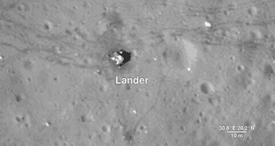
As much as we study the Moon looking for sites to visit, we also look back at places we've already been. This is because the new data that LRO is gathering helps us reinterpret the geology of familiar places, giving scientists a better understanding of the sequence of events in early lunar history.
Here, we descend to the Apollo 17 landing site in the Taurus-Littrow valley, which is deeper than the Grand Canyon. The LRO camera is even able to capture a view of the bottom half of the Apollo 17 Lunar Lander, which still sits on the surface, as well as the rover vehicle. These images help preserve our accomplishment of human exploration on the Moon's surface.
North Pole

Finally, we reach the North Pole. Like the South Pole, there are areas that are in permanent shadow and others that bask in nearly perpetual light. LRO scientists have taken detailed brightness and terrain measurements of the North Pole in order to model these areas of sunlight and shadow through time. Sunlit peaks and crater rims here may be ideal locations for generating solar power for future expeditions to the Moon.
LRO was designed as a one-year mission. Now in its ninth year, the spacecraft and the data emphasize the power of long-term data collection. Thanks to its many orbits around the Moon, we have been able to expand on lunar science from the Apollo missions while paving the way for future lunar exploration. And as the mission continues to gather data, it will provide us with many more opportunities to take a tour of our Moon.
And HERE's the full “Tour of the Moon” video:
We hope you enjoyed the tour. If you'd like to explore the moon further, please visit moon.nasa.gov and moontrek.jpl.nasa.gov.
Make sure to follow @NASAMoon on Twitter for the latest lunar updates and photos.
Make sure to follow us on Tumblr for your regular dose of space: http://nasa.tumblr.com
Solar System: 10 Things to Know This Week
Need some space?
Here are 10 perspective-building images for your computer desktop and mobile device wallpaper.
These are all real images, sent very recently by our planetary missions throughout the solar system.
1. Our Sun

Warm up with this view from our Solar Dynamics Observatory showing active regions on the Sun in October 2017. They were observed in a wavelength of extreme ultraviolet light that reveals plasma heated to over a million degrees.
Downloads Desktop: 1280 x 800 | 1600 x 1200 | 1920 x 1200 Mobile: 1440 x 2560 | 1080 x 1920 | 750 x 1334
2. Jupiter Up-Close

This series of enhanced-color images shows Jupiter up close and personal, as our Juno spacecraft performed its eighth flyby of the gas giant planet on Sept. 1, 2017.
Downloads Desktop: 1280 x 800 | 1600 x 1200 | 1920 x 1200 Mobile: 1440 x 2560 | 1080 x 1920 | 750 x 1334
3. Saturn’s and Its Rings

With this mosaic from Oct. 28, 2016, our Cassini spacecraft captured one of its last looks at Saturn and its main rings from a distance.
Downloads Desktop: 1280 x 800 | 1600 x 1200 | 1920 x 1200 Mobile: 1440 x 2560 | 1080 x 1920 | 750 x 1334
4. Gale Crater on Mars

This look from our Curiosity Mars rover includes several geological layers in Gale crater to be examined by the mission, as well as the higher reaches of Mount Sharp beyond. The redder rocks of the foreground are part of the Murray formation. Pale gray rocks in the middle distance of the right half of the image are in the Clay Unit. A band between those terrains is "Vera Rubin Ridge," where the rover is working currently. The view combines six images taken with the rover's Mast Camera (Mastcam) on Jan. 24, 2017.
Downloads Desktop: 1280 x 800 | 1600 x 1200 | 1920 x 1200 Mobile: 1440 x 2560 | 1080 x 1920 | 750 x 1334
5. Sliver of Saturn

Cassini peers toward a sliver of Saturn's sunlit atmosphere while the icy rings stretch across the foreground as a dark band on March 31, 2017. This view looks toward the unilluminated side of the rings from about 7 degrees below the ring plane.
Downloads Desktop: 1280 x 800 | 1600 x 1200 | 1920 x 1200 Mobile: 1440 x 2560 | 1080 x 1920 | 750 x 1334
6. Dwarf Planet Ceres

This image of the limb of dwarf planet Ceres shows a section of the northern hemisphere, as seen by our Dawn mission. Prominently featured is Occator Crater, home of Ceres' intriguing "bright spots." The latest research suggests that the bright material in this crater is comprised of salts left behind after a briny liquid emerged from below.
Downloads Desktop: 1280 x 800 | 1600 x 1200 | 1920 x 1200 Mobile: 1440 x 2560 | 1080 x 1920 | 750 x 1334
7. Martian Crater

This image from our Mars Reconnaissance Orbiter (MRO) shows a crater in the region with the most impressive known gully activity in Mars' northern hemisphere. Gullies are active in the winter due to carbon dioxide frost, but northern winters are shorter and warmer than southern winters, so there is less frost and less gully activity.
Downloads Desktop: 1280 x 800 | 1600 x 1200 | 1920 x 1200 Mobile: 1440 x 2560 | 1080 x 1920 | 750 x 1334
8. Dynamic Storm on Jupiter

A dynamic storm at the southern edge of Jupiter's northern polar region dominates this Jovian cloudscape, courtesy of Juno. This storm is a long-lived anticyclonic oval named North North Temperate Little Red Spot 1. Citizen scientists Gerald Eichstädt and Seán Doran processed this image using data from the JunoCam imager.
Downloads Desktop: 1280 x 800 | 1600 x 1200 | 1920 x 1200 Mobile: 1440 x 2560 | 1080 x 1920 | 750 x 1334
9. Rings Beyond Saturn’s Sunlit Horizon

This false-color view from the Cassini spacecraft gazes toward the rings beyond Saturn's sunlit horizon. Along the limb (the planet's edge) at left can be seen a thin, detached haze.
Downloads Desktop: 1280 x 800 | 1600 x 1200 | 1920 x 1200 Mobile: 1440 x 2560 | 1080 x 1920 | 750 x 1334
10. Saturn’s Ocean-Bearing Moon Enceladus

Saturn's active, ocean-bearing moon Enceladus sinks behind the giant planet in a farewell portrait from Cassini. This view of Enceladus was taken by NASA's Cassini spacecraft on Sept. 13, 2017. It is among the last images Cassini sent back before its mission came to an end on Sept. 15, after nearly 20 years in space.
Downloads Desktop: 1280 x 800 | 1600 x 1200 | 1920 x 1200 Mobile: 1440 x 2560 | 1080 x 1920 | 750 x 1334
Applying Wallpaper: 1. Click on the screen resolution you would like to use. 2. Right-click on the image (control-click on a Mac) and select the option 'Set the Background' or 'Set as Wallpaper' (or similar).
Places to look for more of our pictures include solarsystem.nasa.gov/galleries, images.nasa.gov and www.jpl.nasa.gov/spaceimages.
Make sure to follow us on Tumblr for your regular dose of space: http://nasa.tumblr.com
Here’s What Actually Happens Inside Our Lunar Lab
Water is a precious resource -- especially on the Moon! In the near future, robotic rovers may roam the Moon’s poles in search of hidden reservoirs of water beneath the lunar surface. But traversing the poles can be a perilous journey. Depending on the Sun’s position in the sky and the way that its light falls on the surface, hazards such as boulders and craters can be difficult, if not impossible, to see.

Inside our Lunar Lab at Ames Research Center, researchers are using Hollywood light kits and a giant sandbox filled with 8 tons of artificial Moon dirt to simulate driving conditions at the poles. The research aims to provide rovers and their human supervisors with 3-D hazard maps of the Moon’s terrain, helping them to avoid potential obstacles that lie ahead.
Here’s how it works:
STEP 1: GENERATE A MOON MAP

Researchers begin with a map of the Moon’s terrain that’s randomly generated by a computer. Each scene is based on observations made from lunar orbit. The map indicates the number, location and size of features like rocks and craters that should be placed inside the 12x12-foot testbed.
STEP 2: BUILD A MOONSCAPE

Using the map as a guide, researchers build the terrain by hand with everyday tools. The terrain is then dusted with a top layer of artificial Moon dirt to eliminate shovel and brush marks.
STEP 3: CAPTURE IMAGES

Lights are positioned at different locations around the testbed. One by one, the lights are switched on and off while a camera captures images of the terrain. Notice how the appearance of the terrain changes depending on the source of illumination.
STEP 4: CREATE A 3-D MODEL

Using a computer algorithm, a 3-D hazard detection model of the terrain is generated from the images. The model provides important information about the size of an obstacle, its height and where it’s located.
STEP 5: GO EXPLORING

With this technique, researchers can teach a rover to recognize the effect of different lighting conditions on the Moon’s poles. The tool could come in handy for future lunar rover missions like Resource Prospector, which will use a drill to search for subsurface water and other compounds on the Moon.
Make sure to follow us on Tumblr for your regular dose of space: http://nasa.tumblr.com