Your gateway to endless inspiration
Hurricanejose - Blog Posts
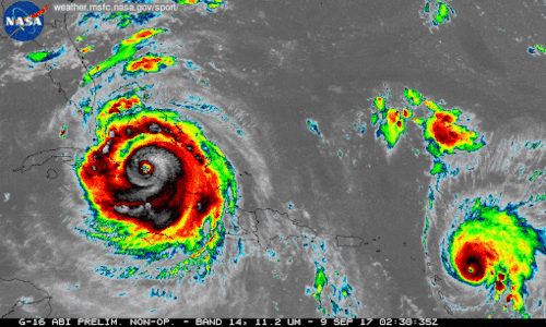
We're using our unique vantage point in space to provide observations and data of Hurricane Irma and other tropical storms. Hurricanes Irma and Jose are seen here in a 12-hour long infrared loop. Scientists monitor storms in infrared to closely monitor clouds and storm intensity. We continue to provide satellite imagery for these storms, tracking its trajectory, force and precipitation to inform forecasters at the National Hurricane Center.
As these storms continue their westward drive in the coming days, they will be passing over waters that are warmer than 30 degrees Celsius (86 degrees Fahrenheit)—hot enough to sustain a category 5 storm. Warm oceans, along with low wind shear, are two key ingredients that fuel and sustain hurricanes. Get the latest imagery and data from us at www.nasa.gov/hurricane For information on making preparations for Hurricanes, visit the FEMA website at: ready.gov/hurricanes. Credit: NASA-SPoRT/NOAA
Make sure to follow us on Tumblr for your regular dose of space: http://nasa.tumblr.com.