Your gateway to endless inspiration
Sdo - Blog Posts
Our sun is dynamic and ever-changing. On Friday, July 14, a solar flare and a coronal mass ejection erupted from the same, large active region. The coils arcing over this active region are particles spiraling along magnetic field lines.
Solar flares are explosions on the sun that send energy, light and high-speed particles into space. Such flares are often associated with solar magnetic storms known as coronal mass ejections. While these are the most common solar events, the sun can also emit streams of very fast protons – known as solar energetic particle (SEP) events – and disturbances in the solar wind known as corotating interaction regions (CIRs).
Learn more HERE.
Make sure to follow us on Tumblr for your regular dose of space: http://nasa.tumblr.com
The Moon Just Photobombed NASA’s Solar Dynamics Observatory
On May 25, 2017, the moon photobombed one of our sun-watching satellites by passing directly between the satellite and the sun.

The Solar Dynamics Observatory, or SDO, orbits Earth and watches the sun nearly 24/7 — except when another body, like the moon, gets in the way. These lunar photobombs are called transits, the generic term for when any celestial body passes in front of another.
Transits are one way we detect distant worlds. When a planet in another star system passes in front of its host star, it blocks some of the star’s light so the star appears slightly dimmer. By monitoring changes in a star’s light over time, scientists can deduce the presence of a planet, and even determine what its atmosphere is like. This method has been used to discover thousands of planets, including the TRAPPIST-1 planets.

SDO sees lunar transits about twice a year, and this one lasted about an hour with the moon covering about 89 percent of the sun at the peak of its journey across the sun’s face.
When they’re seen from Earth, we call lunar transits by another name: eclipses.

Solar eclipses are just a special kind of transit where the moon blocks all or part of our view of the sun. Since SDO’s view of the sun was only partially blocked, it saw a partial eclipse. Later this year, on Aug. 21, a total eclipse will be observable from the ground: The moon will completely block the sun’s face in some parts of the US, creating a total solar eclipse on a 70-mile-wide stretch of land, called the path of totality, that runs from Oregon to South Carolina.
Throughout the rest of North America — and even in parts of South America, Africa, Europe and Asia — the moon will partially obscure the sun, creating a partial eclipse. SDO will also witness this partial eclipse.

Total solar eclipses are incredible, cosmic coincidences: The sun is about 400 times wider than the moon, but it also happens to be 400 times farther away, so the sun and moon appear to be the same size in our sky. This allows the moon to completely block the sun when they line up just right.

Within the path of totality, the moon completely obscures the sun’s bright face, revealing the comparatively faint corona — the sun’s pearly-white outer atmosphere.

It’s essential to observe eye safety during an eclipse. You must use proper eclipse glasses or an indirect viewing method when any part of the sun’s surface is exposed, whether during the partial phases of an eclipse, or just on a regular day. If you’re in the path of totality, you may look at the eclipse ONLY during the brief moments of totality.

A total solar eclipse is one of nature’s most awe-inspiring sights, so make your plans now for August 21! You’ll also be able to see the eclipse cross the country that day through the eyes of NASA – including views of the partial eclipse from SDO – on NASA TV and at nasa.gov.
Learn more about the August eclipse — including where, when, and how to safely see it — at eclipse2017.nasa.gov and follow along on Twitter @NASASun.
The magnetic field lines between a pair of active regions formed a beautiful set of swaying arches, seen in this footage captured by our Solar Dynamics Observatory on April 24-26, 2017.
These arches, which form a connection between regions of opposite magnetic polarity, are visible in exquisite detail in this wavelength of extreme ultraviolet light. Extreme ultraviolet light is typically invisible to our eyes, but is colorized here in gold.
Take a closer look: https://go.nasa.gov/2pGgYZt
Make sure to follow us on Tumblr for your regular dose of space: http://nasa.tumblr.com
Cascading loops on the surface of the sun highlight an active region that had just rotated into view of our solar-observing spacecraft. We have observed this phenomenon numerous times, but this one was one of the longest and clearest sequences we have seen in years.
The bright loops are actually charged particles spinning along the magnetic field lines! The action was captured in a combination of two wavelengths of extreme ultraviolet light over a period of about 20 hours.
Take a closer look: https://sdo.gsfc.nasa.gov/gallery/potw/item/798
Make sure to follow us on Tumblr for your regular dose of space: http://nasa.tumblr.com
Solar System: Things to Know This Week
Reaching out into space yields benefits on Earth. Many of these have practical applications — but there's something more than that. Call it inspiration, perhaps, what photographer Ansel Adams referred to as nature's "endless prospect of magic and wonder."
Our ongoing exploration of the solar system has yielded more than a few magical images. Why not keep some of them close by to inspire your own explorations? This week, we offer 10 planetary photos suitable for wallpapers on your desktop or phone. Find many more in our galleries. These images were the result of audacious expeditions into deep space; as author Edward Abbey said, "May your trails be crooked, winding, lonesome, dangerous, leading to the most amazing view."

1. Martian Selfie
This self-portrait of NASA's Curiosity Mars rover shows the robotic geologist in the "Murray Buttes" area on lower Mount Sharp. Key features on the skyline of this panorama are the dark mesa called "M12" to the left of the rover's mast and pale, upper Mount Sharp to the right of the mast. The top of M12 stands about 23 feet (7 meters) above the base of the sloping piles of rocks just behind Curiosity. The scene combines approximately 60 images taken by the Mars Hand Lens Imager, or MAHLI, camera at the end of the rover's robotic arm. Most of the component images were taken on September 17, 2016.
800 x 600
1024 x 768
1280 x 1024
1600 x 1200
1280 x 800
1440 x 900
1920 x 1200

2. The Colors of Pluto
NASA's New Horizons spacecraft captured this high-resolution, enhanced color view of Pluto on July 14, 2015. The image combines blue, red and infrared images taken by the Ralph/Multispectral Visual Imaging Camera (MVIC). Pluto's surface sports a remarkable range of subtle colors, enhanced in this view to a rainbow of pale blues, yellows, oranges, and deep reds. Many landforms have their own distinct colors, telling a complex geological and climatological story that scientists have only just begun to decode.
800 x 600
1024 x 768
1280 x 1024
1600 x 1200
1280 x 800
1440 x 900
1920 x 1200

3. The Day the Earth Smiled
On July 19, 2013, in an event celebrated the world over, our Cassini spacecraft slipped into Saturn's shadow and turned to image the planet, seven of its moons, its inner rings — and, in the background, our home planet, Earth. This mosaic is special as it marks the third time our home planet was imaged from the outer solar system; the second time it was imaged by Cassini from Saturn's orbit, the first time ever that inhabitants of Earth were made aware in advance that their photo would be taken from such a great distance.
800 x 600
1024 x 768
1280 x 1024
1600 x 1200
1280 x 800
1440 x 900
1920 x 1200

4. Looking Back
Before leaving the Pluto system forever, New Horizons turned back to see Pluto backlit by the sun. The small world's haze layer shows its blue color in this picture. The high-altitude haze is thought to be similar in nature to that seen at Saturn's moon Titan. The source of both hazes likely involves sunlight-initiated chemical reactions of nitrogen and methane, leading to relatively small, soot-like particles called tholins. This image was generated by combining information from blue, red and near-infrared images to closely replicate the color a human eye would perceive.
800 x 600
1024 x 768
1280 x 1024
1600 x 1200
1280 x 800
1440 x 900
1920 x 1200

5. Catching Its Own Tail
A huge storm churning through the atmosphere in Saturn's northern hemisphere overtakes itself as it encircles the planet in this true-color view from Cassini. This picture, captured on February 25, 2011, was taken about 12 weeks after the storm began, and the clouds by this time had formed a tail that wrapped around the planet. The storm is a prodigious source of radio noise, which comes from lightning deep within the planet's atmosphere.
800 x 600
1024 x 768
1280 x 1024
1600 x 1200
1280 x 800
1440 x 900
1920 x 1200

6. The Great Red Spot
Another massive storm, this time on Jupiter, as seen in this dramatic close-up by Voyager 1 in 1979. The Great Red Spot is much larger than the entire Earth.
800 x 600
1024 x 768
1280 x 1024
1600 x 1200
1280 x 800
1440 x 900
1920 x 1200

7. More Stormy Weather
Jupiter is still just as stormy today, as seen in this recent view from NASA's Juno spacecraft, when it soared directly over Jupiter's south pole on February 2, 2017, from an altitude of about 62,800 miles (101,000 kilometers) above the cloud tops. From this unique vantage point we see the terminator (where day meets night) cutting across the Jovian south polar region's restless, marbled atmosphere with the south pole itself approximately in the center of that border. This image was processed by citizen scientist John Landino. This enhanced color version highlights the bright high clouds and numerous meandering oval storms.
800 x 600
1024 x 768
1280 x 1024
1600 x 1200
1280 x 800
1440 x 900
1920 x 1200

8. X-Ray Vision
X-rays stream off the sun in this image showing observations from by our Nuclear Spectroscopic Telescope Array, or NuSTAR, overlaid on a picture taken by our Solar Dynamics Observatory (SDO). The NuSTAR data, seen in green and blue, reveal solar high-energy emission. The high-energy X-rays come from gas heated to above 3 million degrees. The red channel represents ultraviolet light captured by SDO, and shows the presence of lower-temperature material in the solar atmosphere at 1 million degrees.
800 x 600
1024 x 768
1280 x 1024
1600 x 1200
1280 x 800
1440 x 900
1920 x 1200

9. One Space Robot Photographs Another
This image from NASA's Mars Reconnaissance Orbiter shows Victoria crater, near the equator of Mars. The crater is approximately half a mile (800 meters) in diameter. It has a distinctive scalloped shape to its rim, caused by erosion and downhill movement of crater wall material. Since January 2004, the Mars Exploration Rover Opportunity has been operating in the region where Victoria crater is found. Five days before this image was taken in October 2006, Opportunity arrived at the rim of the crater after a drive of more than over 5 miles (9 kilometers). The rover can be seen in this image, as a dot at roughly the "ten o'clock" position along the rim of the crater. (You can zoom in on the full-resolution version here.)
800 x 600
1024 x 768
1280 x 1024
1600 x 1200
1280 x 800
1440 x 900
1920 x 1200

10. Night Lights
Last, but far from least, is this remarkable new view of our home planet. Last week, we released new global maps of Earth at night, providing the clearest yet composite view of the patterns of human settlement across our planet. This composite image, one of three new full-hemisphere views, provides a view of the Americas at night from the NASA-NOAA Suomi-NPP satellite. The clouds and sun glint — added here for aesthetic effect — are derived from MODIS instrument land surface and cloud cover products.
Full Earth at night map
Americas at night
Discover more lists of 10 things to know about our solar system HERE.
Make sure to follow us on Tumblr for your regular dose of space: http://nasa.tumblr.com
Stretched Loops: When an active region rotated over to the edge of the sun, it presented us with a nice profile view of its elongated loops stretching and swaying above it (March 8/9, 2017). These loops are actually charged particles (made visible in extreme ultraviolet light) swirling along the magnetic field lines of the active region. The video covers about 30 hours of activity. Also of note is a darker twisting mass of plasma to the left of the active region being pulled and spun about by magnetic forces.
Credit: Solar Dynamics Observatory, NASA
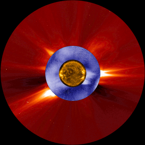
This composite image shows a coronal mass ejection, a type of space weather linked to solar energetic particles, as seen from two space-based solar observatories and one ground-based instrument. The image in gold is from NASA’s Solar Dynamics Observatory, the image in blue is from the Manua Loa Solar Observatory’s K-Cor coronagraph, and the image in red is from ESA and NASA’s Solar and Heliospheric Observatory.
Our constantly-changing sun sometimes erupts with bursts of light, solar material, or ultra-fast energized particles — collectively, these events contribute to space weather. A new study shows that the warning signs of one type of space weather event can be detected tens of minutes earlier than with current forecasting techniques – critical extra time that could help protect astronauts in space.
Credits: NASA/ESA/SOHO/SDO/Joy Ng and MLSO/K-Cor
Seven Years of Tracking the Solar Cycle
Our sun is ever-changing, and a satellite called the Solar Dynamics Observatory has a front-row seat.

On February 11, 2010, we launched the Solar Dynamics Observatory, also known as SDO. SDO keeps a constant eye on the sun, helping us track everything from sunspots to solar flares to other types of space weather that can have an impact on Earth.
After seven years in space, SDO has had a chance to do what few other satellites have been able to do – watch the sun for the majority of a solar cycle in 11 types of light.

The sun’s activity rises and falls in a pattern that lasts about 11 years on average. This is called the solar cycle.
Solar activity can influence Earth. For instance, it’s behind one of Earth’s most dazzling natural events – the aurora.

One of the most common triggers of the aurora is a type of space weather called a coronal mass ejection, which is a billion-ton cloud of magnetic solar material expelled into space at around a million miles an hour.

When these clouds collide with Earth’s magnetic field, they can rattle it, sending particles down into the atmosphere and triggering the auroras. These events can also cause satellite damage and power grid strain in extreme cases.
The sun is in a declining activity phase, so coronal mass ejections will be less common over the next few years, as will another one of the main indicators of solar activity – sunspots.

Sunspots are created by twisted knots of magnetic field. Solar material in these tangled regions is slightly cooler than the surrounding areas, making them appear dark in visible light.

The tangled magnetic field that creates sunspots also causes most solar activity, so more sunspots means more solar activity, and vice versa. Humans have been able to track the solar cycle by counting sunspots since the 17th century.

Image: Houghton Library, Harvard University, *IC6.G1333.613ia
The peak of the sun’s activity for this cycle, called solar maximum, was in 2014.

Now, we’re heading towards the lowest solar activity for this solar cycle, also known as solar minimum. As solar activity declines, the number of sunspots decreases. We sometimes go several days without a single visible sunspot.

But there’s much more to the story than sunspots – SDO also watches the sun in a type of light called extreme ultraviolet. This type of light is invisible to human eyes and is blocked by our atmosphere, so we can only see the sun this way with satellites.

Extreme ultraviolet light reveals different layers of the sun’s atmosphere, helping scientists connect the dots between the sunspots that appear in visible light and the space weather that impacts us here on Earth.
SDO keeps an eye on the sun 24/7, and you can see near real-time images of the sun in 11 types of light at sdo.gsfc.nasa.gov/data.
Solar System: Things to Know This Week
Learn about Earth’s nearest neighbors, the moon, near Earth asteroids, and more this week.

1. Cosmic, Man
The fifth International Cosmic Day will take place on Nov. 2. This event will bring students, teachers and scientists together to talk and learn about cosmic rays, energetic particles from deep space. Participants will learn more about cosmic rays, and can also carry out their own measurements and get in contact with groups all over the world to compare and discuss their results.
+ Join in

2. Meet Our Neighbors
The number of near-Earth asteroids (NEAs) discovered now tops 15,000, with an average of 30 added each week. "While no known NEA currently poses a risk of impact with Earth over the next 100 years," says NASA Planetary Defense Officer Lindley Johnson. "We've found mostly the larger asteroids...we have a lot more of the smaller, but still potentially hazardous ones, to find."
+ Find out how we keep watch

3. Written in the Scars
The moon wasn't always so lucky when it came to avoiding impacts. New results from our Gravity Recovery and Interior Laboratory (GRAIL) mission are providing insights into the huge impacts that dominated the early history of Earth's moon--and other solid worlds like Earth and Mars.
+ See more

4. Raw Beauty
Our Cassini spacecraft regularly returns spectacular images from Saturn. What you may not realize is that even before they've been processed by Cassini imaging specialists, these pictures are published online in raw, unprocessed form, almost the moment they come down to Earth.
+ See for yourself

5. Photobomb!
On Oct. 30, 2016, the Solar Dynamics Observatory, or SDO, experienced a partial solar eclipse in space when it caught the moon passing in front of the sun. The lunar transit lasted an hour, with the moon covering about 59 percent of the sun at the peak of its journey across the face of the sun. The moon's shadow occasionally obstructs SDO's otherwise constant view of the sun. The shadow's edge is sharp and distinct, since the moon has no atmosphere that would distort sunlight.
Discover the full list of 10 things to know about our solar system this week HERE.
Make sure to follow us on Tumblr for your regular dose of space: http://nasa.tumblr.com
Mercury In the Spotlight
For more than seven hours on Monday, May 9, Mercury will be visible as a tiny black dot crossing the face of the sun. This rare event – which happens only slightly more than once a decade – is called a transit.

Although Mercury whips around the sun every 88 days – over four times faster than Earth – the three bodies rarely align. Because Mercury orbits in a plane 7 degrees tilted from Earth’s orbit, it usually darts above or below our line of sight to the sun. As a result, a Mercury transit happens only about 13 times a century. The last one was in 2006, and the next one isn’t until 2019.

When: On May 9, shortly after 7:00 a.m. EDT, Mercury will appear as a tiny black dot against a blazing backdrop, traversing the sun’s disk over seven and a half hours. Mercury will cross the edge of the sun (ingress) after 7:00 a.m. EDT. The mid-transit point will occur a little after 10:45 a.m. EDT, with egress around 2:30 p.m. EDT.
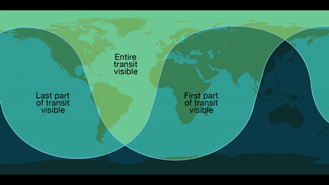
Where: Skywatchers in Western Europe, South America and eastern North America will be able to see the entirety of the transit. The entire 7.5-hour path across the sun will be visible across the Eastern U.S. – with magnification and proper solar filters – while those in the West can observe the transit in progress at sunrise.

Safety!
Unlike the 2012 Venus transit of the sun, Mercury is too small to be visible without magnification from a telescope or high-powered binoculars. Both must have safe solar filters made of specially-coated glass or Mylar; you can never look directly at the sun. We’re offering several avenues for the public to view the event without specialized and costly equipment, including images on NASA.gov, a one-hour NASA Television special, and social media coverage.

The Science…Why are Planetary Transits Important?
Transits like this allowed scientists in the 17th century to make the first estimates of Earth’s distance from the sun. Transit observations over the past few centuries have also helped scientists study everything from the atmosphere of Venus to the slight shifts in Mercury’s orbit that could only be explained by the theory of general relativity. Because we know Mercury’s size and location precisely, this transit will help scientists calibrate telescopes on solar observatories SDO, SOHO, and Hinode.

Transits can also teach us more about planets – both in and out of our solar system. The Venus transit in 2012 provided observations of the planet's atmosphere. Transits are also the main way we find planets outside the solar system, called exoplanets.

The transit method looks for a drop in the brightness of a star when a planet passes in front of it. This method will not find every planet – only those that happen to cross our line of sight from Earth to the star. But with enough sensitivity, the transit method through continuous monitoring is a great way to detect small, Earth-size planets, and has the advantage of giving us both the planet’s size (from the fraction of starlight blocked), as well as its orbit (from the period between transits). Our Kepler/K2 mission uses this method to find exoplanets, as will the Transiting Exoplanet Survey Satellites, or TESS, following its launch in 2017/2018.
We will stream a live program on NASA TV and the agency’s Facebook page from 10:30 to 11:30 a.m. -- an informal roundtable during which experts representing planetary, heliophysics and astrophysics will discuss the science behind the Mercury transit. Viewers can ask questions via Facebook and Twitter using #AskNASA.
Make sure to follow us on Tumblr for your regular dose of space: http://nasa.tumblr.com
Solar System: Things to Know This Week
The solar system is vast, and exploring it requires not one expedition, but many. From the sun to the Earth to the depths of space beyond Pluto, an entire fleet of spacecraft is pushing back the frontiers of knowledge. Scientists and engineers around the world work together on dozens of missions, and the results of their work unfold on a daily basis. During any given week, astronauts and robotic spacecraft return thousands of pictures and other data from Earth orbit and from half a dozen other worlds.
The result? It’s nothing short of a visual and intellectual feast. For example, all of the following images were obtained over the course of one week during January this year.
The same missions that took these pictures are still at work – they may be photographing Saturn or transmitting a report from Mars as you read this.
1. The Sun

From its clear vantage point in Earth orbit, our Solar Dynamics Observatory (SDO) observes our nearby star almost continuously. This image shows activity on the sun’s surface on Jan. 18. You can also get similar pictures from SDO daily!
2. The Earth from Afar

The DSCOVR satellite orbits the Earth at a distance of nearly a million miles (1.5 million kilometers). It’s Earth Polychromatic Imaging Camera (EPIC) keeps a steady watch on the home planet. This is how the world turned on Jan. 20. Get the latest daily images from EPIC HERE.
3. Mars from Above

The team that manages the Mars Reconnaissance Orbiter (MRO) recently celebrated a decade of observing the Red Planet. MRO took this detailed look at dunes and rocky buttes in Danielson Crater on Jan. 24. It was 3:06 p.m., local Mars time. On the right stide of the image, dust devils have left tracks in the sand.
4. Comet 67/P

The European Space Agency’s Rosetta probe caught this look at the surface of Comet 67/P from a distance of just 46 miles (75 kilometers) on Jan. 23.
5. Saturn

On the same day (Jan. 23), our Cassini spacecraft continued its odyssey of nearly two decades in space, bringing us this look at the sixth planet. See the latest images from Cassini HERE.
Want to learn more? Read our full list of the 10 things to know this week about the solar system HERE.
Make sure to follow us on Tumblr for your regular dose of space: http://nasa.tumblr.com