Your gateway to endless inspiration
Hurricanes - Blog Posts
For those who have been looking, I hope you find this.
For everyone else, I don't argue on the internet. Talk to the wall 🧱
GoFundMe for students in Caribbean

My former classmates' homes have been affected by the hurricane in the Caribbean, losing their homes and having little to no supplies available for them. I'd appreciate if people can spread this link and donate if they can to help them out.
In a Warming World, NASA’s Eyes Offer Crucial Views of Hurricanes
June 1 marks the start of hurricane season in the Atlantic Ocean. Last year’s hurricane season saw a record-setting 30 named storms. Twelve made landfall in the United States, also a record. From space, NASA has unique views of hurricanes and works with other government agencies -- like the National Oceanographic and Atmospheric Administration (NOAA) -- to better understand individual storms and entire hurricane seasons.

Here, five ways NASA is changing hurricane science:
1. We can see storms from space
From space, we can see so much more than what’s visible to the naked eye. Among our missions, NASA and NOAA have joint satellite missions monitoring storms in natural color -- basically, what our eyes see -- as well as in other wavelengths of light, which can help identify features our eyes can’t on their own. For instance, images taken in infrared can show the temperatures of clouds, as well as allow us to track the movement of storms at night.

2. We can see inside hurricanes in 3D
If you’ve ever had a CT scan or X-ray done, you know how important 3D imagery can be to understanding what’s happening on the inside. The same concept applies to hurricanes. Our Global Precipitation Measurement mission’s radar and microwave instruments can see through storm clouds to see the precipitation structure of the storm and measure how much total rain is falling as a result of the storm. This information helps scientists understand how the storm may change over time and understand the risk of severe flooding.
We can even virtually fly through hurricanes!

3. We’re looking at how climate change affects hurricane behavior
Climate change is likely causing storms to behave differently. One change is in how storms intensify: More storms are increasing in strength quickly, a process called rapid intensification, where hurricane wind speeds increase by 35 mph (or more) in just 24 hours.
In 2020, a record-tying nine storms rapidly intensified. These quick changes in storm strength can leave communities in their path without time to properly prepare.
Researchers developed a machine learning model that could more accurately detect rapidly intensifying storms.

It’s not just about how quickly hurricanes gain strength. We’re also looking at how climate change may be causing storms to move more slowly, which makes them more destructive. These “stalled” storms can slow to just a few miles an hour, dumping rain and damaging winds on one location at a time. Hurricane Dorian, for example, stalled over Grand Bahama and left catastrophic damage in its wake. Hurricanes Harvey and Florence experienced stalling as well, both causing major flooding.

4. We can monitor damage done by hurricanes
Hurricane Maria reshaped Puerto Rico’s forests. The storm destroyed so many large trees that the overall height of the island’s forests was shortened by one-third. Measurements from the ground, the air, and space gave researchers insights into which trees were more susceptible to wind damage.

Months after Hurricane Maria, parts of Puerto Rico still didn’t have power. Using satellite data, researchers mapped which neighborhoods were still dark and analyzed demographics and physical attributes of the areas with the longest wait for power.

5. We help communities prepare for storms and respond to their aftermath
The data we collect is available for free to the public. We also partner with other federal agencies, like the Federal Emergency Management Agency (FEMA), and regional and local governments to help prepare for and understand the impacts of disasters like hurricanes.
In 2020, our Disasters Program provided data to groups in Alabama, Louisiana, and Central America to identify regions significantly affected by hurricanes. This helps identify vulnerable communities and make informed decisions about where to send resources.

The 2021 Atlantic hurricane season starts today, June 1. Our colleagues at NOAA are predicting another active season, with an above average number of named storms. At NASA, we’re developing new technology to study how storms form and behave, including ways to understand Earth as a system. Working together with our partners at NOAA, FEMA and elsewhere, we’re ready to help communities weather another year of storms.
Bonus: We see storms on other planets, too!
Earth isn’t the only planet with storms. From dust storms on Mars to rains made of glass, we study storms and severe weather on planets in our solar system and beyond. Even the Sun has storms. Jupiter’s Great Red Spot, for instance, is a hurricane-like storm larger than the entire Earth.

Make sure to follow us on Tumblr for your regular dose of space: http://nasa.tumblr.com.
Far from Westeros, a Three-Eyed Raven Helps NASA Find Its Way
Perched on the outside of the International Space Station is Raven—a technology-filled module that helps NASA develop a relative navigation capability, which is essentially autopilot for spacecraft. Raven has been testing technologies to enable autonomous rendezvous in space, which means the ability to approach things in space without human involvement, even from the ground.

Developed by the Satellite Servicing Projects Division (SSPD), our three-eyed Raven has visible, infrared, and Lidar sensors and uses those “eyes” to image and track visiting spacecraft as they come and go from the space station. Although Raven is all-seeing, it only sees all in black and white. Color images do not offer an advantage in the case of Raven and Restore-L, which also utilize infrared and Lidar sensors.
The data from Raven’s sensors is sent to its processor, which autonomously sends commands that swivel Raven on its gimbal, or pointing system. When Raven turns using this system, it is able to track a vehicle. While these maneuvers take place, NASA operators evaluate the movements and make adjustments to perfect the relative navigation system technologies.

A few days ago, Raven completed its 21st observation of a spacecraft when it captured images of Northrop Grumman’s Cygnus vehicle delivering science investigations and supplies as part of its 11th commercial resupply services mission, including another SSPD payload called the Robotic External Leak Locator.

And just last month, Raven celebrated its two-year anniversary in space, marking the occasion with an observation of SpaceX’s Crew Dragon during the Demo-1 mission.

What is this—a spacecraft for ants??
While this shot of Dragon isn’t terribly impressive because of where the spacecraft docked on station, Raven has captured some truly great images when given the right viewing conditions.
From SpaceX Dragon resupply mission observations…

…to Cygnus supply vehicles.

Raven has observed six unique types of spacecraft.
It has also conducted a few observations not involving spacecraft, including the time it captured Hurricane Irma…

…or the time it captured station’s Dextre arm removing the Robotic Refueling Mission 3 payload, another mission developed by SSPD, from the Dragon spacecraft that delivered it to the orbiting laboratory.


Thus far, Raven has had a great, productive life aboard the station, but its work isn’t done yet! Whether it’s for Restore-L, which will robotically refuel a satellite, or getting humans to the Moon or Mars, the technologies Raven is demonstrating for a relative navigation system will support future NASA missions for decades to come.

Make sure to follow us on Tumblr for your regular dose of space: http://nasa.tumblr.com
The 2017 Atlantic Hurricane Season: What We Learned

The 2017 Atlantic hurricane season was among the top ten most active seasons in recorded history. Our experts are exploring what made this year particularly active and the science behind some of the biggest storms to date.

After a period of 12 years without a Category 3 or higher hurricane making landfall in the U.S., Hurricane Harvey made landfall over Texas as a Category 4 hurricane this August.
Harvey was also the biggest rainfall event ever to hit the continental U.S. with estimates more than 49 inches of rain.

Data like this from our Global Precipitation Measurement Mission, which shows the amount of rainfall from the storm and temperatures within the story, are helping scientists better understand how storms develop.

The unique vantage point of satellites can also help first responders, and this year satellite data helped organizations map out response strategies during hurricanes Harvey, Irma and Maria.

In addition to satellites, we use ground stations and aircraft to track hurricanes.

We also use the capabilities of satellites like Suomi NPP and others that are able to take nighttime views. In this instance, we were able to view the power outages in Puerto Rico. This allowed first responders to see where the location of impacted urban areas.

The combined effort between us, NOAA, FEMA and other federal agencies helps us understand more about how major storms develop, how they gain strength and how they affect us.

To learn more about how we study storms, go to www.nasa.gov/Hurricanes.
Make sure to follow us on Tumblr for your regular dose of space: http://nasa.tumblr.com.
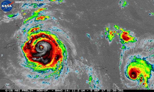
We're using our unique vantage point in space to provide observations and data of Hurricane Irma and other tropical storms. Hurricanes Irma and Jose are seen here in a 12-hour long infrared loop. Scientists monitor storms in infrared to closely monitor clouds and storm intensity. We continue to provide satellite imagery for these storms, tracking its trajectory, force and precipitation to inform forecasters at the National Hurricane Center.
As these storms continue their westward drive in the coming days, they will be passing over waters that are warmer than 30 degrees Celsius (86 degrees Fahrenheit)—hot enough to sustain a category 5 storm. Warm oceans, along with low wind shear, are two key ingredients that fuel and sustain hurricanes. Get the latest imagery and data from us at www.nasa.gov/hurricane For information on making preparations for Hurricanes, visit the FEMA website at: ready.gov/hurricanes. Credit: NASA-SPoRT/NOAA
Make sure to follow us on Tumblr for your regular dose of space: http://nasa.tumblr.com.
How Do Hurricanes Form?
Hurricanes are the most violent storms on Earth. People call these storms by other names, such as typhoons or cyclones, depending on where they occur.

The scientific term for ALL of these storms is tropical cyclone. Only tropical cyclones that form over the Atlantic Ocean or eastern and central Pacific Ocean are called “hurricanes.”

Whatever they are called, tropical cyclones all form the same way.
Tropical cyclones are like giant engines that use warm, moist air as fuel. That is why they form only over warm ocean waters near the equator. This warm, moist air rises and condenses to form clouds and storms.

As this warmer, moister air rises, there's less air left near the Earth's surface. Essentially, as this warm air rises, this causes an area of lower air pressure below.

This starts the 'engine' of the storm. To fill in the low pressure area, air from surrounding areas with higher air pressure pushes in. That “new” air near the Earth's surface also gets heated by the warm ocean water so it also gets warmer and moister and then it rises.

As the warm air continues to rise, the surrounding air swirls in to take its place. The whole system of clouds and wind spins and grows, fed by the ocean’s heat and water evaporating from the surface.
As the storm system rotates faster and faster, an eye forms in the center. It is vey calm and clear in the eye, with very low air pressure.

Tropical cyclones usually weaken when they hit land, because they are no longer being “fed” by the energy from the warm ocean waters. However, when they move inland, they can drop many inches of rain causing flooding as well as wind damage before they die out completely.
There are five types, or categories, of hurricanes. The scale of categories is called the Saffir-Simpson Hurricane Scale and they are based on wind speed.

How Does NASA Study Hurricanes?
Our satellites gather information from space that are made into pictures. Some satellite instruments measure cloud and ocean temperatures. Others measure the height of clouds and how fast rain is falling. Still others measure the speed and direction of winds.

We also fly airplanes into and above hurricanes. The instruments aboard planes gather details about the storm. Some parts are too dangerous for people to fly into. To study these parts, we use airplanes that operate without people.
Learn more about this and other questions by exploring NASA Space Place and the NASA/NOAA SciJinks that offer explanations of science topics for school kids.
Make sure to follow us on Tumblr for your regular dose of space: http://nasa.tumblr.com.
Credits: NASA Space Place & NASA/NOAA SciJinks
All Eyes on Harvey
Our Earth-observing satellites, along with the cameras and crew of the International Space Station, are keeping a watchful eye over Hurricane Harvey as it churns in the Gulf of Mexico. When Hurricane Harvey blows ashore over coastal Texas on Friday night, it will likely be the first major hurricane to make landfall in the United States since 2005.

Above is a view of Harvey from NOAA's GOES-East satellite captured on Aug. 25 at 10:07 a.m. EDT (1407 UTC) clearly showing the storm’s eye as Harvey nears landfall in the southeastern coast of Texas. As Hurricane Harvey continued to strengthen, we analyzed the storm’s rainfall, cloud heights and cloud top temperatures.

Above, the Global Precipitation Mission (GPM) core observatory satellite flew almost directly above intensifying Hurricane Harvey on August 24, 2017 at 6:30 p.m. EDT (2230 UTC) and we used the Microwave Imager instrument to peer through dense storm clouds to reveal the location of intense rainfall bands near the center of the hurricane.
And from the International Space Station, cameras were pointed towards Harvey as the orbiting laboratory passed overhead 250 miles above the Earth. The video above includes views from the space station recorded on August 24, 2017 at 6:15 p.m. Eastern Time.
The National Hurricane Center expects Harvey to be a category 3 storm on the Saffir-Simpson scale—with winds higher than 111 miles (179 kilometers) per hour—when it makes landfall. It will likely produce a storm surge of 6 to 12 feet (2 to 4 meters) and drop between 15 and 25 inches (38 and 63 centimeters) of rain in some areas—enough to produce life-threatening flash floods.
For updated forecasts, visit the National Hurricane Center. Ensure you are prepared for Hurricanes. Get tips and more at FEMA’s Ready site. Get the latest updates from NASA satellites by visiting our Hurricane site.
Make sure to follow us on Tumblr for your regular dose of space: http://nasa.tumblr.com
Eight Small Satellites Will Give Us a New Look Inside Hurricanes

The same GPS technology that helps people get where they’re going in a car will soon be used in space in an effort to improve hurricane forecasting. The technology is a key capability in a NASA mission called the Cyclone Global Navigation Satellite System (CYGNSS).

The CYGNSS mission, led by the University of Michigan, will use eight micro-satellite observatories to measure wind speeds over Earth’s oceans, increasing the ability of scientists to understand and predict hurricanes. Each microsatellite observatory will make observations based on the signals from four GPS satellites.

The CYGNSS microsatellite observatories will only receive signals broadcast directly to them from GPS satellites already orbiting the Earth and the reflection of the same satellite’s signal reflected from the Earth’s surface. The CYGNSS satellites themselves will not broadcast.

The use of eight microsatellite observatories will decrease the revisit time as compared with current individual weather satellites. The spacecraft will be deployed separately around the planet, with successive satellites passing over the same region every 12 minutes.
This will be the first time that satellites can peer through heavy tropical rainfall into the middle of hurricanes and predict how intense they are before and during landfall.

As the CYGNSS and GPS constellations orbit around the Earth, the interaction of the two systems will result in a new image of wind speed over the entire tropics every few hours, compared to every few days for a single satellite.

Another advantage of CYGNSS is that its orbit is designed to measure only in the tropics…where hurricanes develop and are most often located. The focus on tropical activity means that the instruments will be able to gather much more useful data on weather systems exclusively found in the tropics. This data will ultimately be used to help forecasters and emergency managers make lifesaving decisions.
Launch!

CYGNSS launched at 8:37 a.m. EST on Thursday, Dec. 15, from our Kennedy Space Center in Florida. CYGNSS launched aboard an Orbital ATK Pegasus XL rocket, deployed from Orbital’s “Stargazer” L-1011 carrier aircraft.
Pegasus is a winged, three-stage solid propellant rocket that can launch a satellite into low Earth orbit. How does it work? Great question!

After takeoff, the aircraft (which looks like a commercial airplane..but with some special quirks) flies to about 39,000 feet over the ocean and releases the rocket.

After a five-second free fall in a horizontal position, the Pegasus first stage ignites. The aerodynamic lift, generated by the rocket’s triangle-shaped wing, delivers the payload into orbit in about 10 minutes.
Pegasus is used to deploy small satellites weighing up to 1,000 pounds into low Earth orbit.
And success! The eight CYGNSS satellites were successfully deployed into orbit!
Make sure to follow us on Tumblr for your regular dose of space: http://nasa.tumblr.com
Ten Years After Katrina

As we remember the devastation that Hurricane Katrina caused ten years ago, we also look to the improvements made in the past decade in storm prediction and forecasting.
Hurricane Katrina impacted many people, businesses and communities; and even two NASA facilities were hit by the storm. Marshall Space Flight Center and Michoud Assembly Facility were both hit by the harsh storm (seen below).

During Hurricane Katrina in 2005, our satellites were hard at work monitoring and watching the storm from above. Thanks to the higher resolution models we have today, simulations can recreate historical storms, like the below of Hurricane Katrina. Scientists can then study these and learn about past events.

Surprisingly, the United States hasn’t experienced the landfall of a Category 3 hurricane or lager since 2005. This is the longest period of time that has passed without a major hurricane making landfall in the U.S. since reliable records began in 1850.

Although we don’t know when a severe storm will form, we do know that advancements in technology can help us better prepare and predict its path. So, on this ten year mark of this devastating storm, we look back to remember what we saw: https://www.flickr.com/photos/gsfc/sets/72157656646633089