Your gateway to endless inspiration
Storm - Blog Posts


In Roman mythology, the god Jupiter drew a veil of clouds around himself to hide his mischief. It was only Jupiter's wife, the goddess Juno, who could peer through the clouds and reveal Jupiter's true nature. Our @NASAJuno spacecraft is looking beneath the clouds of the massive gas giant, not seeking signs of misbehavior, but helping us to understand the planet's structure and history... Now, @NASAJuno just published its first findings on the amount of water in the gas giant’s atmosphere. The Juno results estimate that at the equator, water makes up about 0.25% of the molecules in Jupiter's atmosphere — almost three times that of the Sun. An accurate total estimate of this water is critical to solving the mystery of how our solar system formed.
The JunoCam imager aboard Juno captured this image of Jupiter's southern equatorial region on Sept. 1, 2017. The bottom image is oriented so Jupiter's poles (not visible) run left-to-right of frame.
Image credit: NASA/JPL-Caltech/SwRI/MSSS/Kevin M. Gill
10 Ground-breaking Earth Satellite Images from 2018
In 2018, our satellites captured beautiful imagery from throughout the solar system and beyond. However, some of our favorite visualizations are of this very planet. While this list is by no means exhaustive, it does capture some Earth satellite images from this year that are both visually striking as well as scientifically informative. This list also represents a broad variety of Earth’s features, as well as satellite instrumentation. Take a journey with our eyes in the sky!
10. Hurricane Florence

Before making landfall, Hurricane Florence churned in the Atlantic for a full two weeks — making it among the longest-lived cyclones of the 2018 season. When it finally did hit land on Sep. 14, the storm devastated the southeastern U.S. coast with intense winds, torrential rains and severe flooding.
This natural-color image was acquired by MODIS on the Terra Satellite on Sep. 12, 2018.
Images like this, as well as other satellite information, were used to anticipate the impact of the storm. Our Disasters Program created flood proxy maps that were shared with the Federal Emergency Management Agency (FEMA) and the National Guard to estimate how many and which communities would be most affected by the storm, in order to help prepare recovery efforts ahead of time.
9. Australia’s Lake Eyre Basin

The Lake Eyre Basin covers one-sixth of Australia and is one of the world’s largest internally draining river systems. However, the rivers supported by this system are ephemeral, meaning that they only run for short periods of time following unpredictable rain — the rest of the time, the Basin is a dry, arid desert.
However, when the heavy rain comes, the basin erupts in an explosion of green. In this false-color image captured by the Operational Land Imager (OLI) on Landsat 8 on Apr. 25, 2018, you can see how the vegetation completely envelops the spaces where the water has receded. (Flood water is indicated by light blue, and vegetation is indicated by light green.)
Satellites are an excellent tool for tracking greening events that are followed by flooding. These events offer opportunities for predictive tools as well as recreation.
8. Alaska’s Chukchi Sea

A Monet painting comes to life as the Chukchi Sea swirls with microscopic marine algae.
This image was captured off the Alaskan coast by OLI on Landsat 8 on Jun. 18, 2018. After the Arctic sea ice breaks up each spring, the nutrient-rich Bering Sea water mixes with the nutrient-poor Alaskan coastal water. Each type of water brings with it a different type of phytoplankton and the surface waters have just enough light for the algae to populate and flourish. The result is these mesmerizing patterns of turquoise and green.
This image represents one piece of much larger, incredibly complex ecosystem. While one would not normally associate the breaking up of sea ice with phytoplankton blooms, it is an intricate process of the phytoplankton life cycle. The size of the blooms have varied greatly from year to year, and experts are unsure why. Images like these can help scientists track the development of these blooms and link it to other environmental changes.
7. Hawaii’s Kilauea

Sometimes fresh lava is best viewed in infrared.
This false-color image of Kilauea, captured by OLI on Landsat 8 on May 23, 2018, shows the infrared signal emitted by lava flowing toward the sea. The purple areas surrounding the glowing lava are clouds lit from below, indicating that this image was taken through a break in the clouds.
The Puʻu ʻŌʻō Kupaianaha eruption has been continuously spewing red-hot lava since 1983, making it the longest eruption at Kilauea in recorded history. However, new fissures opened up this year that forced many to evacuate the area. Hawaii’s largest lake evaporated in hours and hundreds of homes were destroyed in Vacationland and Kapoho.
Imagery, seismometers and ground-based instruments were used to track the underground movement of magma. Infrared imagery can be incredibly helpful in disasters like this when you to view data that cannot be observed with the naked eye.
6. California’s Woolsey Burn Scar

Nothing quite encapsulates the destruction of a wildfire like a photo from outer space.
This image of the Woolsey Fire aftermath in Southern California was captured on Nov. 18, 2018 by the Advanced Spaceborned Thermal Emission and Reflection Radiometer (ASTER) on the Terra satellite. This false-color infrared image has been enhanced to clearly show the burned vegetation (indicated by brown) and the vegetation that survived unscathed (indicated by green).
The Woolsey Fire clearly left its mark, with almost 152 square miles (394 square km) and 88% of the Santa Monica Mountains National Recreation Area badly burned. Images like this one can assist fire managers in the area plan for recovery.
5. Bangladesh’s Padma River

As the years go by, the Padma River grows and shrinks, twists and turns. It never has a fixed shape, and as a result, thousands of people must regularly adapt to the constant changes in the river’s 75-mile (130-km) shoreline.
This image captured on Jan. 20, 2018 by OLI on Landsat 8 depicts one of the major rivers of Bangladesh. For thirty years, scientists have been tracking the erosion of the river with satellite imagery. Combinations of shortwave infrared, near infrared, and visible light are used to detect differences year-to-year in width, depth, and shape of the river. Sometimes the river splits off, but then rejoins again later. These patterns are created by the river carrying and depositing sediment, shaping the curves of the path of water.
Monitoring the Padma River is going to become especially important as a new bridge development project advances in the Char Janajat area. Although the bridge will most certainly help shorten travel times for citizens, nobody is quite sure how the river erosion might affect the construction and vice versa.
4. Alaska’s Yakutat Glacier

It’s hard to believe that Harlequin Lake was once all dry land — but it only started to form once Yakutat Glacier started melting. The lake appeared at the beginning of the twentieth century, and has been growing rapidly ever since.
In this hauntingly beautiful image, captured on Sep. 21 2018 by OLI on Landsat 8, the effect of climate change is apparent — especially when compared to earlier images of the region.
Unless the climate warming starts to reverse very soon — which scientists consider very unlikely — Yakutat could be gone as soon as 2070.
3. South Africa’s Theewaterskloof

Cape Town is a seaside city planted on the tip of South Africa. It’s a city known for its beaches and biodiversity — it also almost became known as the first major city to officially run out of water.
This image of Cape Town’s largest reservoir — Theewaterskloof — was acquired on Jul. 9th, 2018 by OLI on Landsat 8. By the time this photo was taken, the city’s main reservoirs stood at 55%. This was a huge increase from where it stood just six months earlier: just 13%.
The severe water shortage in the region started in 2015, only to become more threatening after three successive and unusually dry years. The entire city was preparing for Day Zero — the day the tap water would be shut off.
Despite forecasts that Day Zero would arrive in April, a combination of heavier rains and local conservation efforts restored the majority of the reservoir.
2. Aerosol Earth

Aerosols are all around us. From the smoke from a fire, to the dust in the wind to the salt in sea spray — these solid particles and liquid droplets are always swirling in our atmosphere, oftentimes unseen.
The Goddard Earth Observing System Forward Processing (GEOS FP) model uses mathematical equations to model what is happening in our atmosphere. The inputs for its equations — temperature, moisture, wind, etc. — come from our satellites and ground sensors.
This visualization was compiled on Aug. 24, 2018 — obviously a busy day for aerosols in our atmosphere. Swirls of sea salt (indicated by blue) reveal typhoons Soulik and Cimaron heading straight towards South Korea and Japan. A haze of black carbon (indicated by red) suffuse from agricultural burning in Africa and large wildfires in North America. And clouds of dust (indicated by purple) float off the Sahara desert.
1. Camp Fire

With nearly a hundred fatalities, hundreds of thousands of acres burned and billions of dollars of damage, the world watched in horror as Camp Fire grew to become the most destructive California wildfire in recorded history.
This image was captured on Nov. 8, 2018 by OLI on Landsat 8 on the same day Camp Fire ignited. It consolidates both visible light and shortwave-infrared light in order to highlight the active fire. Strong winds and dry conditions literally fanned the flames and spread this wildfire like a rash.
This image has not only become the iconic portrait for Camp Fire, it is also sobering representation of how quickly a fire can grow out of control in a short amount of time. Even from space, you can almost smell the massive plumes of smoke and feel the heat of the fires.
Whether you realize it or not, our Earth satellite missions are collecting data everyday in order to monitor environmental changes and prepare for natural disasters. If your interest is piqued by this list, head over to the Earth Observatory. The Earth Observatory updates daily with fresh, new content — brought to you by none other than our eyes in the sky.
Make sure to follow us on Tumblr for your regular dose of space: http://nasa.tumblr.com
The Darkness that Followed Hurricane Michael
Earlier this month, the southeastern United States was struck by Hurricane Michael. After the category 4 storm made landfall on Oct. 10, 2018, Hurricane Michael proceeded to knock out power for at least 2.5 million customers across Florida, Georgia, North Carolina, and Virginia.

In this data visualization, you can clearly see where the lights were taken out in Panama City, Florida. A team of our scientists from Goddard Space Flight Center processed and corrected the raw data to filter out stray light from the Moon, fires, airglow, and any other sources that are not electric lights. They also removed atmosphere interference from dust, haze, and clouds.

In the visualization above, you can see a natural view of the night lights—and a step of the filtering process in an effort to clean up some of the cloud cover. The line through the middle is the path Hurricane Michael took.

Although the damage was severe, tens of thousands of electric power industry workers from all over the country—and even Canada—worked together to restore power to the affected areas. Most of the power was restored by Oct. 15, but some people still need to wait a little longer for the power grids to be rebuilt. Read more here.
Make sure to follow us on Tumblr for your regular dose of space: http://nasa.tumblr.com.

For scientists watching the Red Planet from our orbiters, the past month has been a windfall. "Global" dust storms, where a runaway series of storms create a dust cloud so large they envelop the planet, only appear every six to eight years (that’s 3-4 Mars years). Scientists still don't understand why or how exactly these storms form and evolve.
Read the full story HERE.
Make sure to follow us on Tumblr for your regular dose of space: http://nasa.tumblr.com.
10 Things to Know: Massive Dust Storm on Mars
Massive Martian dust storms have been challenging—and enticing—scientists for decades. Here’s the scoop on Martian dust:

1: Challenging Opportunity
Our Opportunity rover is facing one of the greatest challenges of its 14 ½ year mission on the surface of Mars--a massive dust storm that has turned day to night. Opportunity is currently hunkered down on Mars near the center of a storm bigger than North America and Russia combined. The dust-induced darkness means the solar-powered rover can’t recharge its batteries.

2: One Tough Robot
This isn’t the first time Opportunity has had to wait out a massive storm. In 2007, a monthlong series of severe storms filled the Martian skies with dust. Power levels reached critical lows, but engineers nursed the rover back to health when sunlight returned.

3: Windswept
Martian breezes proved a saving grace for the solar-powered Mars rovers in the past, sweeping away accumulated dust and enabling rovers to recharge and get back to science. This is Opportunity in 2014. The image on the left is from January 2014. The image on the right in March 2014.

4: Dusty Disappointment
Back in 1971, scientists were eager for their first orbital views of Mars. But when Mariner 9 arrived in orbit, the Red Planet was engulfed by a global dust storm that hid most of the surface for a month. When the dust settled, geologists got detailed views of the Martian surface, including the first glimpses of ancient riverbeds carved into the dry and dusty landscape.

5: Dramatic License
As bad as the massive storm sounds, Mars isn’t capable of generating the strong winds that stranded actor Matt Damon’s character on the Red Planet in the movie The Martian. Mars’ atmosphere is too thin and winds are more breezy than brutal. The chore of cleaning dusty solar panels to maintain power levels, however, could be a very real job for future human explorers.

6: Semi-Regular Visitors
Scientists know to expect big dust storms on Mars, but the rapid development of the current one is surprising. Decades of Mars observations show a pattern of regional dust storms arising in northern spring and summer. In most Martian years, nearly twice as long as Earth years, the storms dissipate. But we’ve seen global dust storms in 1971, 1977, 1982, 1994, 2001 and 2007. The current storm season could last into 2019.

7: Science in the Dust
Dust is hard on machines, but can be a boon to science. A study of the 2007 storm published earlier this year suggests such storms play a role in the ongoing process of gas escaping from the top of Mars' atmosphere. That process long ago transformed wetter, warmer ancient Mars into today's arid, frozen planet. Three of our orbiters, the Curiosity rover and international partners are already in position to study the 2018 storm.

8: Adjusting InSight
Mission controllers for Mars InSight lander--due to land on Mars in November--will be closely monitoring the storm in case the spacecraft’s landing parameters need to be adjusted for safety.
Once on the Red Planet, InSight will use sophisticated geophysical instruments to delve deep beneath the surface of Mars, detecting the fingerprints of the processes of terrestrial planet formation, as well as measuring the planet's "vital signs": Its "pulse" (seismology), "temperature" (heat flow probe), and "reflexes" (precision tracking).

9: Martian Weather Report
One saving grace of dust storms is that they can actually limit the extreme temperature swings experienced on the Martian surface. The same swirling dust that blocks out sunlight also absorbs heat, raising the ambient temperature surrounding Opportunity.
Track the storm and check the weather on Mars anytime.

10: Dust: Not Just a Martian Thing
A dust storm in the Sahara can change the skies in Miami and temperatures in the North Atlantic. Earth scientists keep close watch on our home planet’s dust storms, which can darken skies and alter Earth’s climate patterns.
Read the full web version of this article HERE.
Make sure to follow us on Tumblr for your regular dose of space: http://nasa.tumblr.com
5 Things: How Hurricanes Have Changed Puerto Rico’s Forests
In September 2017, Hurricanes Irma and Maria hit Puerto Rico, knocking out critical infrastructure and ransacking the island’s forests. In April and May 2018, a team of our scientists took to the air to take three-dimensional images of Puerto Rico’s forests using Goddard’s Lidar, Hyperspectral, and Thermal Imager (G-LIHT), which uses light in the form of a pulsed laser. By comparing images of the same forests taken by the team before and after the storm, scientists will be able to use those data to study how hurricanes change these important ecosystems.
Here are five ways scientists say the hurricanes have changed Puerto Rico’s forests since making landfall eight months ago:
1. The Canopy Is Bare

One word defines the post-hurricane forest canopy in El Yunque National Forest: Open.
“The trees have been stripped clean,” said NASA Goddard Earth scientist and G-LiHT co-investigator Doug Morton. He was there a year ago, months before the hurricanes would ravage the area. When he returned to the forest in April 2018 to gather measurements of trees on the ground to complement the airborne campaign’s lidar work, he could now see from the mountainside downtown San Juan, which is 45-minutes away by car.
And no canopy means no shade. “Where once maybe a few flecks of sunlight reached the forest floor, now the ground is saturated in light,” Morton said, adding that such a change could have profound consequences for the overall forest ecosystem. For example, some tree seedlings that thrive on a cool forest floor may whither now that daytime temperatures are as much as 4 degrees Celsius (7 degrees Fahrenheit) hotter than they were before the hurricane. Meanwhile, as we shall see, other plants and animals stand to benefit from such changes.
“Who are the winners and losers in this post-hurricane forest ecosystem, and how will that play out in the long run? Those are two of the key questions,” said Morton.
2. Palms Are on the Rise

One species that’s basking in all that sunlight is the Sierra Palm, said Maria Uriarte, a professor of ecology at Columbia University who has researched El Yunque National Forest for 15 years. “Before, the palms were squeezed in with the other trees in the canopy and fighting for sunlight, and now they’re up there mostly by themselves,” she said. “They’re fruiting like crazy right now.”
The secret to their survival: Biomechanics.
“The palm generally doesn’t break because it’s got a flexible stem—it’s got so much play,” Uriarte said. “For the most part, during a storm it sways back and forth and loses its fronds and has a bad hair day and then it’s back to normal.” By contrast, neighboring trees with very dense, strong wood, like the Tabonuco, were snapped in half or completely uprooted by the force of the hurricane winds.
“Palm trees are going to be a major component of the canopy of this forest for the next decade or so,” added Doug Morton. “They’ll help to facilitate recovery by providing some shade and protection as well as structure for both flora and fauna.”
3. Vines Are Creeping Opportunists

Rising noticeably from the post-Hurricane forest floor of El Yunque National Forest are woody vines called lianas. Rooted in the ground, their goal, Morton says, is to climb onto host trees and compete for sunlight at the top. That, combined with the fact that their weight tends to slow tree productivity potential, means they are literally a drag on the forest canopy. As lianas can wind their way around several trees, regions with more of these vines tend to have larger groupings of trees that get pulled down together.
“There’s some indication that vines may be more competitive in a warmer, drier, and more carbon dioxide-rich world,” Morton said. “That’s a hypothesis we’re interested in exploring.”
4. Endangered Parrot Populations Have Taken a Hit

The endangered Iguaca is the last living native parrot species of Puerto Rico. The island’s two Iguaca aviaries have reported a substantial number of deaths in the wild due to the hurricanes. In the forests of Río Abajo, in western central Puerto Rico, about 100 of the roughly 140 wild parrots survived; in El Yunque National Forest in the eastern part of the island, only three of the 53 to 56 wild parrots are known to have pulled through.
“It was a huge blow,” said the U.S. Fish and Wildlife Service’s Tom White, a parrot biologist stationed at the aviary in El Yunque, which took the brunt of Hurricane Maria’s Category 5 winds. Some of the parrots died from injuries received during the storm, while others likely died from increased predation from hawks because there were no longer canopies for them to hide in. The rest succumbed to starvation. The Iguaca subsists on flowers, fruits, seeds, and leaves derived from more than 60 species—but for several months following the storm, the forest was completely defoliated.
Despite the setback, White said he’s optimistic that the Iguaca will rebound. In Río Abajo, the number of wild Iguaca are enough that they should rebound on their own; in El Yunque there are about 227 birds at the aviary—a strong number for continued breeding and eventual release into the forest once conditions improve enough. “One of their main fruit comes from the sierra palm, and they’re now flowering and starting to produce again,” White noted. “It’s probably going to take about another year for things to level out, but the forest is gritty.”
5. Lizards and Frogs: A Mixed Response
When Hurricane Maria stripped the leaves off of trees, changes in the forest microclimate instantly transformed the living conditions for lizards and frogs. Species have reacted differently to the event based on the conditions they are adapted to, said herpetologist Neftali Ríos-López, an associate professor at the University of Puerto Rico-Humacao Campus.

For example, some lizard species are naturally suited to the forest canopy, which is warmer and drier. “After the hurricane, those conditions, which were once exclusive to the canopy, have now been extended down to the forest floor,” Ríos-Lopez said. “As a result, these lizards start displacing and substituting animals that were adapted to the once cooler conditions on the forest floor.”

Likewise, among frog species the red-eyed coquí, with its resistance to temperature and humidity fluctuations and its ability to handle dehydration better than other coquí species, has benefited from the warmer, drier conditions in the forests after the storm. Traditionally a grassland species, they are expanding from the lowlands to the mid- and even high parts of the mountains, Ríos-Lopez said. “Physiologically, what was a disadvantage for that species when the whole island was forested now finds itself in a positive position.” Conversely, forest-acclimated coquí frog species have declined.
That said, as the forests recover, so will many of the species whose numbers have dwindled following the storms. “It will take many years, decades, I would guess,” Ríos-Lopez said.
Our scientists are working with partners from universities and government to use G-LiHT airborne data to inform ground research on forest and other ecosystems not only in Puerto Rico but also throughout the world. To follow their campaigns and keep up with the latest news, find them here: https://gliht.gsfc.nasa.gov.
Make sure to follow us on Tumblr for your regular dose of space: http://nasa.tumblr.com.
What's Made in a Thunderstorm and Faster Than Lightning? Gamma Rays!
A flash of lightning. A roll of thunder. These are normal stormy sights and sounds. But sometimes, up above the clouds, stranger things happen. Our Fermi Gamma-ray Space Telescope has spotted bursts of gamma rays - some of the highest-energy forms of light in the universe - coming from thunderstorms. Gamma rays are usually found coming from objects with crazy extreme physics like neutron stars and black holes.
So why is Fermi seeing them come from thunderstorms?

Thunderstorms form when warm, damp air near the ground starts to rise and encounters colder air. As the warm air rises, moisture condenses into water droplets. The upward-moving water droplets bump into downward-moving ice crystals, stripping off electrons and creating a static charge in the cloud.

The top of the storm becomes positively charged, and the bottom becomes negatively charged, like two ends of a battery. Eventually the opposite charges build enough to overcome the insulating properties of the surrounding air - and zap! You get lightning.

Scientists suspect that lightning reconfigures the cloud's electrical field. In some cases this allows electrons to rush toward the upper part of the storm at nearly the speed of light. That makes thunderstorms the most powerful natural particle accelerators on Earth!

When those electrons run into air molecules, they emit a terrestrial gamma-ray flash, which means that thunderstorms are creating some of the highest energy forms of light in the universe. But that's not all - thunderstorms can also produce antimatter! Yep, you read that correctly! Sometimes, a gamma ray will run into an atom and produce an electron and a positron, which is an electron's antimatter opposite!

The Fermi Gamma-ray Space Telescope can spot terrestrial gamma-ray flashes within 500 miles of the location directly below the spacecraft. It does this using an instrument called the Gamma-ray Burst Monitor which is primarily used to watch for spectacular flashes of gamma rays coming from the universe.

There are an estimated 1,800 thunderstorms occurring on Earth at any given moment. Over the 10 years that Fermi has been in space, it has spotted about 5,000 terrestrial gamma-ray flashes. But scientists estimate that there are 1,000 of these flashes every day - we're just seeing the ones that are within 500 miles of Fermi's regular orbits, which don't cover the U.S. or Europe.
The map above shows all the flashes Fermi has seen since 2008. (Notice there's a blob missing over the lower part of South America. That's the South Atlantic Anomaly, a portion of the sky where radiation affects spacecraft and causes data glitches.)

Fermi has also spotted terrestrial gamma-ray flashes coming from individual tropical weather systems. The most productive system we've seen was Tropical Storm Julio in 2014, which later became a hurricane. It produced four flashes in just 100 minutes!

Learn more about what Fermi's discovered about gamma rays over the last 10 years and how we're celebrating its accomplishments.
Make sure to follow us on Tumblr for your regular dose of space: http://nasa.tumblr.com.
Jupiter's Great Red Spot Getting Taller as it Shrinks
Discover how a team of our scientists has uncovered evidence that Jupiter’s Great Red Spot is growing taller as it gets smaller.
Though once big enough to swallow three Earths with room to spare, Jupiter's Great Red Spot has been shrinking for a century and a half. Nobody is sure how long the storm will continue to contract or whether it will disappear altogether.

A new study suggests that it hasn't all been downhill, though. The storm seems to have increased in area at least once along the way, and it's growing taller as it gets smaller.

Observations of Jupiter date back centuries, but the first confirmed sighting of the Great Red Spot was in 1831. But until then, researchers aren't certain whether earlier observers who saw a red spot on Jupiter were looking at the same storm.

Amy Simon, an expert in planetary atmospheres at our Goddard Space Flight Center in Greenbelt, Maryland, and her team traced the evolution of the Great Red Spot, analyzing its size, shape, color and drift rate. They also looked at the storm's internal wind speeds, when that information was available from spacecraft.

This new study confirms that the storm has been decreasing in diameter overall since 1878 and is now big enough to accommodate just over one Earth at this point. Then again, the historical record indicates the area of the spot grew temporarily in the 1920s. Scientists aren't sure why it grew for a bit.

Because the storm has been contracting, the researchers expected to find the already-powerful internal winds becoming even stronger, like an ice skater who spins faster as she pulls in her arms.

But that's not what is happening. Instead of spinning faster, the storm appears to be forced to stretch up. It's almost like clay being shaped on a potter's wheel. As the wheel spins, an artist can transform a short, round lump into a tall, thin vase by pushing inward with his hands. The smaller he makes the base, the taller the vessel will grow.

The Great Red Spot's color has been deepening, too, becoming is a more intense orange color since 2014. Researchers aren't sure why that's happening, but it's possible that the chemicals coloring the storm are being carried higher into the atmosphere as the spot stretches up. At higher altitudes, the chemicals would be subjected to more UV radiation and would take on a deeper color.

In some ways, the mystery of the Great Red Spot only seems to deepen as the iconic storm gets smaller. Researchers don't know whether the spot will shrink a bit more and then stabilize, or break apart completely.
For more information, go here/watch this:
For the full story, click HERE.
Make sure to follow us on Tumblr for your regular dose of space: http://nasa.tumblr.com.
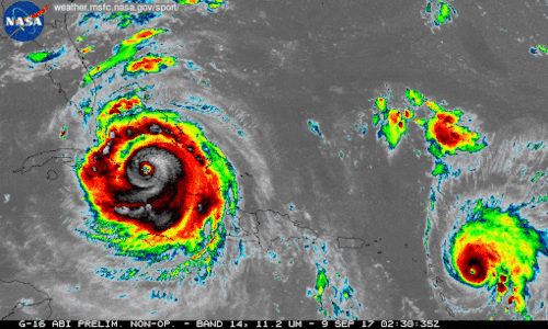
We're using our unique vantage point in space to provide observations and data of Hurricane Irma and other tropical storms. Hurricanes Irma and Jose are seen here in a 12-hour long infrared loop. Scientists monitor storms in infrared to closely monitor clouds and storm intensity. We continue to provide satellite imagery for these storms, tracking its trajectory, force and precipitation to inform forecasters at the National Hurricane Center.
As these storms continue their westward drive in the coming days, they will be passing over waters that are warmer than 30 degrees Celsius (86 degrees Fahrenheit)—hot enough to sustain a category 5 storm. Warm oceans, along with low wind shear, are two key ingredients that fuel and sustain hurricanes. Get the latest imagery and data from us at www.nasa.gov/hurricane For information on making preparations for Hurricanes, visit the FEMA website at: ready.gov/hurricanes. Credit: NASA-SPoRT/NOAA
Make sure to follow us on Tumblr for your regular dose of space: http://nasa.tumblr.com.
Blizzard 2016 from Space
As an intense winter storm approaches the mid-Atlantic this weekend, our satellites watch from above. The storm is expected to produce a wade swath of more than 2 feet of snow in some areas.

The below supercomputer simulation crunched the data to provide a look at the flow of clouds from storm systems around the globe, including the developing blizzard across the eastern United States.
This storm won’t only have a snowy impact on the mid-Atlantic region, but will also cause severe weather in the Gulf Coast. Satellites observe extreme rainfall in the area.

Data from NASA-NOAA Suomi NPP satellite and NOAA’s GOES-East satellite are being used to create images and animation of the movement of this powerful storm. For updates, visit: http://www.nasa.gov/feature/goddard/2016/nasa-sees-major-winter-storm-headed-for-eastern-us

Make sure to follow us on Tumblr for your regular dose of space: http://nasa.tumblr.com
NASA Does Hurricanes

When you think of NASA, you probably think of space. Which makes sense, because space is a huge part of what we do. That being said, here at NASA we are also involved in many other research areas, and even play a role in hurricane weather forecasting.
Our satellites, computer modeling, instruments, aircraft and field missions all contribute to a mix of information used by scientists to get a better understanding of these storms. Aspects of storms from rainfall rates to surface wind speed are all analyzed to help identify the potential for storm formation or intensification.

Currently, our satellites are passing overhead as Hurricane Joaquin (above) travels through the Atlantic Ocean. Our Global Precipitation Measurement, or GPM Core satellite captured images and rainfall rates of the storm. GPM showed a large area of very intense rain, which indicates that large amounts of heat are being released into the storm’s center. This fuels the circulation and provides the means for its intensification.
Maximum sustained winds have increased to near 80 mph and additional strengthening is expected. Joaquin could become a major hurricane during the next few days.

In 2016, we’re launching the Cyclone Global Navigation Satellite System (CYGNSS), which is a constellation of eight small satellites. With this launch, we will be able to better understand the rapid intensification of hurricanes, and improve hurricane intensity forecasts.
In addition to our satellite technology, we also conduct field missions to study hurricanes. In our most recent field mission, we investigated the process that underlie hurricane formation and intensity change in the Atlantic Ocean basin.
Ten Years After Katrina

As we remember the devastation that Hurricane Katrina caused ten years ago, we also look to the improvements made in the past decade in storm prediction and forecasting.
Hurricane Katrina impacted many people, businesses and communities; and even two NASA facilities were hit by the storm. Marshall Space Flight Center and Michoud Assembly Facility were both hit by the harsh storm (seen below).

During Hurricane Katrina in 2005, our satellites were hard at work monitoring and watching the storm from above. Thanks to the higher resolution models we have today, simulations can recreate historical storms, like the below of Hurricane Katrina. Scientists can then study these and learn about past events.

Surprisingly, the United States hasn’t experienced the landfall of a Category 3 hurricane or lager since 2005. This is the longest period of time that has passed without a major hurricane making landfall in the U.S. since reliable records began in 1850.

Although we don’t know when a severe storm will form, we do know that advancements in technology can help us better prepare and predict its path. So, on this ten year mark of this devastating storm, we look back to remember what we saw: https://www.flickr.com/photos/gsfc/sets/72157656646633089