Your gateway to endless inspiration
Nasa - Blog Posts
How the Sun Affects Asteroids in Our Neighborhood
It’s no secret the Sun affects us here on Earth in countless ways, from causing sunburns to helping our houseplants thrive. The Sun affects other objects in space, too, like asteroids! It can keep them in place. It can move them. And it can even shape them.

Asteroids embody the story of our solar system’s beginning. Jupiter’s Trojan asteroids, which orbit the Sun on the same path as the gas giant, are no exception. The Trojans are thought to be left over from the objects that eventually formed our planets, and studying them might offer clues about how the solar system came to be.
Over the next 12 years, NASA’s Lucy mission will visit eight asteroids—including seven Trojans— to help answer big questions about planet formation and the origins of our solar system. It will take the spacecraft about 3.5 years to reach its first destination.
How does the Sun affect what Lucy might find?
Place in Space

Credits: Astronomical Institute of CAS/Petr Scheirich
The Sun makes up 99.8% of the solar system’s mass and exerts a strong gravitational force as a result. In the case of the Trojan asteroids that Lucy will visit, their very location in space is dictated in part by the Sun’s gravity. They are clustered at two Lagrange points. These are locations where the gravitational forces of two massive objects—in this case the Sun and Jupiter—are balanced in such a way that smaller objects (like asteroids or satellites) stay put relative to the larger bodies. The Trojans lead and follow Jupiter in its orbit by 60° at Lagrange points L4 and L5.
Pushing Asteroids Around (with Light!)

The Sun can move and spin asteroids with light! Like many objects in space, asteroids rotate. At any given moment, the Sun-facing side of an asteroid absorbs sunlight while the dark side sheds energy as heat. When the heat escapes, it creates an infinitesimal amount of thrust, pushing the asteroid ever so slightly and altering its rotational rate. The Trojans are farther from the Sun than other asteroids we’ve studied before, and it remains to be seen how sunlight affects their movement.
Cracking the Surface (Also with Light!)

The Sun can break asteroids, too. Rocks expand as they warm and contract when they cool. This repeated fluctuation can cause them to crack. The phenomenon is more intense for objects without atmospheres, such as asteroids, where temperatures vary wildly. Therefore, even though the Trojans are farther from the Sun than rocks on Earth, they’ll likely show more signs of thermal fracturing.
Solar Wind-Swept

Like everything in our solar system, asteroids are battered by the solar wind, a steady stream of particles, magnetic fields, and radiation that flows from the Sun. For the most part, Earth’s magnetic field protects us from this bombardment. Without magnetic fields or atmospheres of their own, asteroids receive the brunt of the solar wind. When incoming particles strike an asteroid, they can kick some material off into space, changing the fundamental chemistry of what’s left behind.
Follow along with Lucy’s journey with NASA Solar System on Instagram, Facebook, and Twitter, and be sure to tune in for the launch at 5 a.m. EDT (09:00 UTC) on Saturday, Oct. 16 at nasa.gov/live.
Make sure to follow us on Tumblr for your regular dose of space!

Two rings to shear them all!
This GIF shows a drop of insulin solution contained by surface tension in the Ring Sheared Drop device as part of an experiment conducted aboard the International Space Station. The device pins a drop of liquid between two rings and rotates one while keeping the other stationary to create shear flow, or a difference in velocity between adjacent liquid layers. Researchers used the device to study protein aggregates called amyloid fibrils, which may be related to diseases such as Alzheimer’s, Parkinson’s, and type 2 diabetes.
Scientists investigating the mechanisms of certain diseases on Earth must contend with the forces of gravity and the interaction between liquids and solid containers. These forces differ from such interfaces in the body, such as those in arteries and brain tissue, and can affect results. The Ring Sheared Drop investigation team developed a device that uses surface tension rather than a solid container to hold liquids, something possible only in microgravity!
Fluid extracted after each run will return to Earth aboard a Dragon capsule on September 30 so researchers can determine the extent of protein fibril formation, study their structure, and compare both to what happens in ground-based controls. Results could improve the fundamental understanding of how amyloid fibrils form and are transported, as well as the effects of shear at fluid interfaces relevant to conditions in the body.
Make sure to follow us on Tumblr for your regular dose of space!

Who is the First Woman? Meet our new graphic novel hero!
Artemis is the first step in the next era of human exploration. This time when we go to the Moon, we're staying, to study and learn more than ever before. We’ll test new technologies and prepare for our next giant leap – sending astronauts to Mars.

Artemis missions will achieve many historic feats, like landing the first woman and first person of color on the Moon.
With today’s release of our graphic novel First Woman: NASA’s Promise for Humanity you don’t have to wait to join us on an inspiring adventure in space.
Meet Commander Callie Rodriguez, the first woman to explore the Moon – at least in the comic book universe.

In Issue No. 1: Dream to Reality, Callie, her robot sidekick RT, and a team of other astronauts are living and working on the Moon in the not-too-distant future. Like any good, inquisitive robot, RT asks Callie how he came to be – not just on the Moon after a harrowing experience stowed in the Orion capsule – but about their origin story, if you will.

From her childhood aspirations of space travel to being selected as an astronaut candidate, Callie takes us on her trailblazing journey to the Moon.

As they venture out to check on a problem at a lunar crater, Callie shares with RT and the crew that she was captivated by space as a kid, and how time in her father’s autobody shop piqued her interest in building things and going places.

Callie learned at a young age that knowledge is gained through both success and failure in the classroom and on the field.

Through disappointment, setbacks, and personal tragedy, Callie pursues her passions and eventually achieves her lifelong dream of becoming an astronaut – a road inspired by the real lives of many NASA astronauts living and working in space today.

So what's up with that lunar crater?
Did Callie pass her math class?
And where did RT come from?
Be a part of the adventure: read (or listen to) the full First Woman story and immerse yourself in a digital experience through our first-ever extended reality-enabled graphic novel.
Make sure to follow us on Tumblr for your regular dose of space!
We Found the Perfect Spot to Land our Moon Rover

After an extensive selection process, we chose the mountainous area west of Nobile Crater at the Moon’s South Pole as the landing site for our first-ever robotic Moon rover. The Volatiles Investigating Polar Exploration Rover, or VIPER, will explore the Moon’s surface and subsurface in search of water and other resources beginning in late 2023. Thanks to past missions, such as satellites orbiting the Moon or impacting its surface, we know there is ice at the Moon’s poles. But how much? And where did it come from? VIPER aims to answer these questions and more by venturing into shadowed craters and visiting other areas of scientific interest over its 100-day mission. The findings will inform future landing sites under the Artemis program and help pave the way toward establishing a long-term human presence on the Moon. Here are five things to know:
The landing site is located just outside the western rim of Nobile Crater at the Moon’s South Pole.

The region has suitable lighting and terrain for our solar-powered rover to navigate.

VIPER will travel up to 15 miles in search of water and other resources.

Its traverse will change depending on what it finds, but it could look like this.

Drivers on Earth will tell the rover where to explore during its 100-day mission.

The VIPER mission is managed by our Ames Research Center in California's Silicon Valley. The approximately 1,000-pound rover will be delivered to the Moon by a commercial vendor as part of our Commercial Lunar Payload Services initiative, delivering science and technology payloads to and near the Moon.
Make sure to follow us on Tumblr for your regular dose of space.
Take a Road Trip through Time with Landsat 9
A lot can change in five decades! How we talk, what we wear – it all evolves. But one thing that’s stayed consistent is our unique view of our home planet from above. Five decades ago, we at NASA partnered with United States Geological Survey (USGS) to launch a satellite called Landsat to see Earth from space. Now, we’re launching Landsat 9 – that’s right, the ninth in the series!

Join us for a road trip through the decades from the idea of an Earth-imaging satellite in the groovy 60s to the launch of Landsat 9 this year. Hop in!

The 60s
Far out! In 1966, USGS proposed a satellite to image land all around our planet. Researchers worked with our scientists and engineers to design the satellite and figure out how it would work.

The 70s
Here’s the lowdown: In 1970, we got approval to build the Earth Resources Technology Satellite, later renamed Landsat 1. The satellite launched in 1972 and provided the first digital data of Earth, repeated at regular intervals, which allows us to see changes as they happen.

The 80s
In 1982, we launched Landsat 4, followed by Landsat 5 in 1984. These two satellites collected more wavelengths of light at higher precision, allowing for natural color images, which is totally radical, dude.

The 90s
Wasssup, 1990s? Landsat 7 launched this decade, collecting even more data than previous Landsat satellites, enough to produce the first hi-res natural color map of remote Antarctica.

The 2000s
In 2008, our partners at USGS made all Landsat data available for free. This gave peeps around the world access to all the data they needed, unlocking innovation and creating economic benefits, like the ability to track crop health from space. Sweet!

The 2010s
In 2013, Landsat 8 began the modern era of Landsat observations. A new style of sensor and ground system made it possible to download much more and better data than ever before. Plus, a partnership with European Space Agency’s Sentinel-2 satellites gives even more regular observations. We heart that!

The 2020s
Now, we’re set to launch Landsat 9, a twin to Landsat 8. Two Landsat satellites with two instruments each will highkey change our view of Earth once again.

Now, on to the next 50 years of Earth observations! Stay tuned to watch Landsat 9 launch and start telling us even more about our home planet.
Make sure to follow us on Tumblr for your regular dose of space.
Which Landsat Image Do You Love?
Feeling competitive? We’ve got a game for you to play in! Tournament Earth: The Landsat Games is happening right now, and as we get to the final entries, the competition is heating up.

You can help us pick the winner by voting for one of the remaining four Landsat images of our home planet! Our competition started with 32 images, divided into categories by what they show: land, water, ice & snow, and human impact.
So, what do you think? Which one of these images is going for gold?
Land
First up, we have an image of the Markha River and surrounding Central Siberian Plateau, acquired in 2020 by Landsat 8. The hypnotic undulations of striping across the landscape carried this image to victory over the rest of the Land images -- a particularly tough category, given that these images all come from Landsat.

Water
It’s not all land, though! The bright blues and greens of this false-color image of the Atchafalaya Delta in Louisiana helped carry it to victory in the Water category. The image, taken in 2020 by Landsat 8, shows a region that’s subject to erosion of land by wind and rising sea levels.

Ice & Snow
Brrr! Did it get cold in here? That’s the finalist from the Ice and Snow category, an image of sea ice around Russia’s New Siberian Islands. The image, collected by Landsat 8 in June 2016, shows sea ice during its annual seasonal breakup.

Human Impact
Humans have been shaping the planet around us for hundreds of years. Some changes, like rice fields in the Sacramento Valley, are visible from space. Landsat 8 collected this false-color image of flooded rice fields in December 2018.

So, now it’s up to you! Which image is your favorite? There can only be one winner of Tournament Earth: The Landsat Games. Get your vote in, and then get ready to watch as we launch the next Landsat satellite, Landsat 9, in September.

The Landsat mission is a partnership between us at NASA and the U.S. Geological Survey. Together, we’ve been using Landsat satellites to collect nearly 50 years of images of our home planet.
Make sure to follow us on Tumblr for your regular dose of space.
Decoding Nebulae
We can agree that nebulae are some of the most majestic-looking objects in the universe. But what are they exactly? Nebulae are giant clouds of gas and dust in space. They’re commonly associated with two parts of the life cycle of stars: First, they can be nurseries forming new baby stars. Second, expanding clouds of gas and dust can mark where stars have died.

Not all nebulae are alike, and their different appearances tell us what's happening around them. Since not all nebulae emit light of their own, there are different ways that the clouds of gas and dust reveal themselves. Some nebulae scatter the light of stars hiding in or near them. These are called reflection nebulae and are a bit like seeing a street lamp illuminate the fog around it.

In another type, called emission nebulae, stars heat up the clouds of gas, whose chemicals respond by glowing in different colors. Think of it like a neon sign hanging in a shop window!

Finally there are nebulae with dust so thick that we’re unable to see the visible light from young stars shine through it. These are called dark nebulae.

Our missions help us see nebulae and identify the different elements that oftentimes light them up.
The Hubble Space Telescope is able to observe the cosmos in multiple wavelengths of light, ranging from ultraviolet, visible, and near-infrared. Hubble peered at the iconic Eagle Nebula in visible and infrared light, revealing these grand spires of dust and countless stars within and around them.

The Chandra X-ray Observatory studies the universe in X-ray light! The spacecraft is helping scientists see features within nebulae that might otherwise be hidden by gas and dust when viewed in longer wavelengths like visible and infrared light. In the Crab Nebula, Chandra sees high-energy X-rays from a pulsar (a type of rapidly spinning neutron star, which is the crushed, city-sized core of a star that exploded as a supernova).

The James Webb Space Telescope will primarily observe the infrared universe. With Webb, scientists will peer deep into clouds of dust and gas to study how stars and planetary systems form.

The Spitzer Space Telescope studied the cosmos for over 16 years before retiring in 2020. With the help of its detectors, Spitzer revealed unknown materials hiding in nebulae — like oddly-shaped molecules and soot-like materials, which were found in the California Nebula.

Studying nebulae helps scientists understand the life cycle of stars. Did you know our Sun got its start in a stellar nursery? Over 4.5 billion years ago, some gas and dust in a nebula clumped together due to gravity, and a baby Sun was born. The process to form a baby star itself can take a million years or more!

After billions more years, our Sun will eventually puff into a huge red giant star before leaving behind a beautiful planetary nebula (so-called because astronomers looking through early telescopes thought they resembled planets), along with a small, dense object called a white dwarf that will cool down very slowly. In fact, we don’t think the universe is old enough yet for any white dwarfs to have cooled down completely.
Since the Sun will live so much longer than us, scientists can't observe its whole life cycle directly ... but they can study tons of other stars and nebulae at different phases of their lives and draw conclusions about where our Sun came from and where it's headed. While studying nebulae, we’re seeing the past, present, and future of our Sun and trillions of others like it in the cosmos.

To keep up with the most recent cosmic news, follow NASA Universe on Twitter and Facebook.
Make sure to follow us on Tumblr for your regular dose of space.
Watch the Perseids Meteor Shower With Us!

Credit: NASA/Bill Ingalls
The Perseids meteor shower is here! It's one of the biggest of the year, and will peak early in the morning on Thursday, August 12, 2021 and Friday, August 13, 2021. To spot them, find a dark area away from bright lights (yes, that includes your phone), and let your eyes acclimate to the night sky. But don't worry – if you can't get away from lights, join us on Facebook, Twitter, and YouTube for a meteor shower livestream hosted by our Marshall Space Flight Center's Meteoroid Environment Office. Get all the details on our Watch the Skies blog.
Make sure to follow us on Tumblr for your regular dose of space.
Discovering the Universe Through the Constellation Orion
Do you ever look up at the night sky and get lost in the stars? Maybe while you’re stargazing, you spot some of your favorite constellations. But did you know there’s more to constellations than meets the eye? They’re not just a bunch of imaginary shapes made up of stars — constellations tell us stories about the universe from our perspective on Earth.

What is a constellation?
A constellation is a named pattern of stars that looks like a particular shape. Think of it like connecting the dots. If you join the dots — stars, in this case — and use your imagination, the picture would look like an object, animal, or person. For example, the ancient Greeks believed an arrangement of stars in the sky looked like a giant hunter with a sword attached to his belt, so they named it after a famous hunter in their mythology, Orion. It’s one of the most recognizable constellations in the night sky and can be seen around the world. The easiest way to find Orion is to go outside on a clear night and look for three bright stars close together in an almost-straight line. These three stars represent Orion's belt. Two brighter stars to the north mark his shoulders, and two more to the south represent his feet.

Credit: NASA/STScI
Over time, cultures around the world have had different names and numbers of constellations depending on what people thought they saw. Today, there are 88 officially recognized constellations. Though these constellations are generally based on what we can see with our unaided eyes, scientists have also invented unofficial constellations for objects that can only be seen in gamma rays, the highest-energy form of light.
Perspective is everything
The stars in constellations may look close to each other from our point of view here on Earth, but in space they might be really far apart. For example, Alnitak, the star at the left side of Orion's belt, is about 800 light-years away. Alnilam, the star in the middle of the belt, is about 1,300 light-years away. And Mintaka, the star at the right side of the belt, is about 900 light-years away. Yet they all appear from Earth to have the same brightness. Space is three-dimensional, so if you were looking at the stars that make up the constellation Orion from another part of our galaxy, you might see an entirely different pattern!

The superstars of Orion
Now that we know a little bit more about constellations, let’s talk about the supercool cosmic objects that form them – stars! Though over a dozen stars make up Orion, two take center stage. The red supergiant Betelgeuse (Orion's right shoulder) and blue supergiant Rigel (Orion's left foot) stand out as the brightest members in the constellation.

Credit: Derrick Lim
Betelgeuse is a young star by stellar standards, about 10 million years old, compared to our nearly 5 billion-year-old Sun. The star is so huge that if it replaced the Sun at the center of our solar system, it would extend past the main asteroid belt between Mars and Jupiter! But due to its giant mass, it leads a fast and furious life.

Betelgeuse is destined to end in a supernova blast. Scientists discovered a mysterious dimming of Betelgeuse in late 2019 caused by a traumatic outburst that some believed was a precursor to this cosmic event. Though we don’t know if this incident is directly related to an imminent supernova, there’s a tiny chance it might happen in your lifetime. But don't worry, Betelgeuse is about 550 light-years away, so this event wouldn't be dangerous to us – but it would be a spectacular sight.
Rigel is also a young star, estimated to be 8 million years old. Like Betelgeuse, Rigel is much larger and heavier than our Sun. Its surface is thousands of degrees hotter than Betelgeuse, though, making it shine blue-white rather than red. These colors are even noticeable from Earth. Although Rigel is farther from Earth than Betelgeuse (about 860 light-years away), it is intrinsically brighter than its companion, making it the brightest star in Orion and one of the brightest stars in the night sky.

Credit: Rogelio Bernal Andreo
Buckle up for Orion’s belt
Some dots that make up constellations are actually more than one star, but from a great distance they look like a single object. Remember Mintaka, the star at the far right side of Orion's belt? It is not just a single star, but actually five stars in a complex star system.

Credit: X-ray: NASA/CXC/GSFC/M. Corcoran et al.; Optical: Eckhard Slawik
Sword or a stellar nursery?
Below the three bright stars of Orion’s belt lies his sword, where you can find the famous Orion Nebula. The nebula is only 1,300 light-years away, making it the closest large star-forming region to Earth. Because of its brightness and prominent location just below Orion’s belt, you can actually spot the Orion Nebula from Earth! But with a pair of binoculars, you can get a much more detailed view of the stellar nursery. It’s best visible in January and looks like a fuzzy “star” in the middle of Orion’s sword.

More to discover in constellations
In addition to newborn stars, Orion also has some other awesome cosmic objects hanging around. Scientists have discovered exoplanets, or planets outside of our solar system, orbiting stars there. One of those planets is a giant gas world three times more massive than Jupiter. It’s estimated that on average there is at least one planet for every star in our galaxy. Just think of all the worlds you may be seeing when you look up at the night sky!
It’s also possible that the Orion Nebula might be home to a black hole, making it the closest known black hole to Earth. Though we may never detect it, because no light can escape black holes, making them invisible. However, space telescopes with special instruments can help find black holes. They can observe the behavior of material and stars that are very close to black holes, helping scientists find clues that can lead them closer to discovering some of these most bizarre and fascinating objects in the cosmos.

Next time you go stargazing, remember that there’s more to the constellations than meets the eye. Let them guide you to some of the most incredible and mysterious objects of the cosmos — young stars, brilliant nebulae, new worlds, star systems, and even galaxies!

To keep up with the most recent stellar news, follow NASA Universe on Twitter and Facebook.
Make sure to follow us on Tumblr for your regular dose of space!
Hubble’s Guide to Viewing Deep Fields
They say a picture is worth a thousand words, but no images have left a greater impact on our understanding of the universe quite like the Hubble Space Telescope’s deep fields. Like time machines, these iconic images transport humanity billions of light-years back in time, offering a glimpse into the early universe and insight into galaxy evolution!

You’ve probably seen these images before, but what exactly do we see within them? Deep field images are basically core samples of our universe. By peering into a small portion of the night sky, we embark on a journey through space and time as thousands of galaxies appear before our very eyes.
So, how can a telescope the size of a school bus orbiting 340 miles above Earth uncover these mind-boggling galactic masterpieces? We’re here to break it down. Here’s Hubble’s step-by-step guide to viewing deep fields:
Step 1: Aim at the darkness
Believe it or not, capturing the light of a thousand galaxies actually begins in the dark. To observe extremely faint galaxies in the farthest corners of the cosmos, we need minimal light interference from nearby stars and other celestial objects. The key is to point Hubble’s camera at a dark patch of sky, away from the outer-edge glow of our own galaxy and removed from the path of our planet, the Sun, or the Moon. This “empty” black canvas of space will eventually transform into a stunning cosmic mosaic of galaxies.

The first deep field image was captured in 1995. In order to see far beyond nearby galaxies, Hubble’s camera focused on a relatively empty patch of sky within the constellation Ursa Major. The results were this step-shaped image, an extraordinary display of nearly 3,000 galaxies spread across billions of light-years, featuring some of the earliest galaxies to emerge shortly after the big bang.
Step 2: Take it all in
The universe is vast, and peering back billions of years takes time. Compared to Hubble’s typical exposure time of a few hours, deep fields can require hundreds of hours of exposure over several days. Patience is key. Capturing and combining several separate exposures allows astronomers to assemble a comprehensive core slice of our universe, providing key information about galaxy formation and evolution. Plus, by combining exposures from different wavelengths of light, astronomers are able to better understand galaxy distances, ages, and compositions.

The Hubble Ultra Deep Field is the deepest visible-light portrait of our universe. This astonishing display of nearly 10,000 galaxies was imaged over the course of 400 Hubble orbits around Earth, with a total of 800 exposures captured over 11.3 days.
Step 3: Go beyond what’s visible
The ability to see across billions of light-years and observe the farthest known galaxies in our universe requires access to wavelengths beyond those visible to the human eye. The universe is expanding and light from distant galaxies is stretched far across space, taking a long time to reach us here on Earth. This phenomenon, known as “redshift,” causes longer wavelengths of light to appear redder the farther they have to travel through space. Far enough away, and the wavelengths will be stretched into infrared light. This is where Hubble’s infrared vision comes in handy. Infrared light allows us to observe light from some of the earliest galaxies in our universe and better understand the history of galaxy formation over time.

In 2009, Hubble observed the Ultra Deep Field in the infrared. Using the Near Infrared Camera and Multi-Object Spectrometer, astronomers gathered one of the deepest core samples of our universe and captured some of the most distant galaxies ever observed.
Step 4: Use your time machine
Apart from their remarkable beauty and impressive imagery, deep field images are packed with information, offering astronomers a cosmic history lesson billions of years back in time within a single portrait. Since light from distant galaxies takes time to reach us, these images allow astronomers to travel through time and observe these galaxies as they appear at various stages in their development. By observing Hubble’s deep field images, we can begin to discover the questions we’ve yet to ask about our universe.

Credit: NASA, ESA, R. Bouwens and G. Illingworth (University of California, Santa Cruz)
Hubble’s deep field images observe galaxies that emerged as far back as the big bang. This image of the Hubble Ultra Deep Field showcases 28 of over 500 early galaxies from when the universe was less than one billion years old. The light from these galaxies represent different stages in their evolution as their light travels through space to reach us.
Step 5: Expand the cosmic frontier
Hubble’s deep fields have opened a window to a small portion of our vast universe, and future space missions will take this deep field legacy even further. With advancements in technologies and scientific instruments, we will soon have the ability to further uncover the unimaginable.


Slated for launch in late 2021, NASA’s James Webb Space Telescope will offer a new lens to our universe with its impressive infrared capabilities. Relying largely on the telescope’s mid-infrared instrument, Webb will further study portions of the Hubble deep field images in greater detail, pushing the boundaries of the cosmic frontier even further.
And there you have it, Hubble’s guide to unlocking the secrets of the cosmos! To this day, deep field images remain fundamental building blocks for studying galaxy formation and deepening not only our understanding of the universe, but our place within it as well.
Still curious about Hubble Deep Fields? Explore more and follow along on Twitter, Facebook, and Instagram with #DeepFieldWeek!
Make sure to follow us on Tumblr for your regular dose of space!
Dr. Beach’s Top 10 Beaches of 2021
For more than 30 years, Dr. Beach, aka Dr. Stephen Leatherman, has created an annual Top 10 Beach list. A professor and coastal geomorphologist at Florida International University, Dr. Beach factors in 50 different criteria including water color, sand softness, wave size, water temperature and more.
As we get ready to launch Landsat 9 this fall, we’re taking a tour of Dr. Beach’s Top 10 US beaches of 2021 as seen by Landsat 8.
10. Coast Guard Beach, Cape Cod, Massachusetts

Coast Guard Beach is located just north of the remote Nauset Inlet on Outer Cape Cod, Massachusetts. Except for the picturesque old white Coast Guard station that still sits atop the glacial bluffs, there is no development here; the best way to reach this beach is by bicycle from the Salt Pond Visitor’s Center or shuttle bus.
First mapped by Champlain in 1605, the shifting sands of this inlet are clearly visible in the Landsat image. This location is also at the point where the glacial sea cliffs transcend into a barrier beach (e.g., sand spit) that provides protection for the lagoon and development of lush salt marshes.
“In my early days as a Professor at Boston University and later at the University of Massachusetts at Amherst, I spent many summer and some winter-time days conducting scientific studies along this barrier beach.” – Dr. Beach
Landsat 8 collected this image of Coast Guard Beach on May 1, 2021.
9. Beachwalker Park, Kiawah Island, South Carolina

Beachwalker Park is a public beach located on the southern part of Kiawah Island, South Carolina. This barrier island in the Charleston area is 10-miles long and features a fine grained, hard-packed beach that can be traversed easily by bicycle.
This Landsat image shows a huge accumulation of sand as a series of shoals on the south end of the island, which can be reached from Beachwalker Park. These sandy shoals will eventually coalesce, becoming an extension of the sand spit that is the south end of Kiawah Island.
“In the early 2000s, I served as the beach consultant to the Town of Kiawah Island because their world-famous golf course on the north end was being threatened by severe erosion. It was necessary to artificially bypass some sand on the north end of the island so that the normal flow of sand along the island was reinstated, saving the outermost link of this PGA golf course.” – Dr. Beach
Landsat 8 collected this image of Beachwalker Park on April 9, 2021.
8. Coronado Beach, San Diego, California

Coronado Beach in San Diego is the toast of Southern California with some of the warmest and safest water on the Pacific coast. This 100-meter-wide beach is an oasis of subtropical vegetation, unique Mediterranean climate, and fine sparkling sand.
The harbor serves as a major port for the Navy’s Pacific fleet, the home port for several aircraft carriers. The docks and the crossing airplane runways for the Naval base are visible in this Landsat image.
“I really enjoy visiting this beautiful beach as well as having lunch and drinks, taking advantage of the hotel’s beachside service.” – Dr. Beach
Landsat 8 collected this image of Coronado Beach on April 23, 2020.
7. Caladesi Island State Park, Dunedin Clearwater, Florida

Caladesi Island State Park is located in the small town of Dunedin on the Southwest Florida coast. The stark white undeveloped beach is composed of crystalline quartz sand which is soft and cushy at the water’s edge, inviting one to take a dip in the sparkling clear waters.
While island is still in the Park’s name, Caladesi is no longer a true island as shown on the Landsat image--it is now connected to Clearwater Beach.
“Caladesi is located in the Tampa area, but it seems like a world away on this getaway island.” – Dr. Beach
Landsat 8 collected this image of Caladesi Island State Park on April 9, 2021.
6. Duke Kahanamoku Beach, Oahu, Hawaii

Duke Kahanamoku Beach is named for the famous native Hawaiian who was a big-board surfer and introduced surfing as a sport to mainland Americans and indeed the world.
One of the prominent features on this Landsat image is Diamondhead with its circular shape near the coast. This large cone of an extinct volcano provides the iconic backdrop for photos of Waikiki Beach.
“This is my favorite spot at the world-famous Waikiki Beach where you can both play in the surf and swim in the calm lagoonal waters.” – Dr. Beach
Landsat 8 collected this image of Duke Kahanamoku Beach on May 17, 2020.
5. Lighthouse Beach, Buxton, Outer Banks of North Carolina

Lighthouse Beach in the village of Buxton is located at Cape Hatteras, the most northern cape in the Outer Banks of North Carolina. This lifeguarded beach is the number one surfing spot on the US Atlantic Coast as the large offshore sand banks, known as Diamond Shoals, cause wave refraction focusing wave energy on this beach.
The Landsat image shows the seaward growth of south flank of Cape Hatteras as evidenced by the parallel lines of beach ridges.
“It is fun to walk down the narrow sand spit, more exposed at low tide, as waves are approaching from both directions because of the bending of the waves.” – Dr. Beach
Landsat 8 collected this image of Lighthouse Beach on May 3, 2020.
4. St. George Island State Park, Florida Panhandle

St. George Island State Park, located on the Florida panhandle and far from urban areas, is a favorite destination for beachgoers, anglers and bird watchers as nature abounds. Like other beaches on the panhandle, this long barrier island has a sugary fine, white sand beach.
In this Landsat image, St. George can be seen north of the bridge that links this barrier island to the mainland. The enclosed bay behind St. George Island is fairly shallow and the water much less clear as shown on the Landsat image, but it is not polluted.
“Besides swimming in the crystal-clear Gulf of Mexico waters, I enjoy beachcombing and shelling. While this island was hit hard in 2018 by Hurricane Michael, it has substantially recovered as there was little development to be impacted.” – Dr. Beach
Landsat 8 collected this image of St. George Island State Park on October 13, 2020.
3. Ocracoke Lifeguard Beach, Outer Banks of North Carolina

Ocracoke Lifeguarded Beach at the southern end of Cape Hatteras National Seashore was the first seashore to be incorporated into the National Park Service system.
The Landsat image shows Ocracoke to the north as separated by an inlet from Portsmouth Island. The village of Ocracoke was built at the wide area of the island where it was protected from oceanic waves during coastal storms which include both winter nor’easters and hurricanes.
“Ocracoke was once the home of the most infamous pirate Blackbeard and is still a very special place—my favorite getaway beach.” – Dr. Beach
Landsat 8 collected this image of Ocracoke Lifeguard Beach on May 3, 2020.
2. Cooper’s Beach, Southampton, New York

Cooper’s Beach in the tony town of Southampton on the south shore of Long Island, New York is shielded from the cold Labrador current, making for a fairly long summer swimming season. The white quartz sand is medium to coarse grained with some pebbles, making the beach slope fairly steeply into the water.
This Landsat image shows the fairly large coastal pond named Mecox Bay to the east with Shinnecock Inlet and Bay also displayed to the west. Coopers Beach is hundreds of yards wide, made of grainy white quartz sand and is backed by large sand dunes covered by American beach grass.
“I spent several decades conducting scientific studies of this very interest oceanic shoreline because it is so dynamic and the beachfront real estate so expensive. Some of the most gorgeous and expensive residential houses in the United States are located in the world-famous Hamptons.” – Dr. Beach
Landsat 8 collected this image of Coopers Beach on August 30, 2019.
1. Hapuna Beach State Park, Big Island Hawaii

Hapuna Beach State Park is a white coral sand beach that resides in a landscape dominated by dark brown lava flows on the Big Island of Hawaii. The crystal-clear water is perfect for swimming, snorkeling, and scuba diving during the summer months in contrast to winter big-wave days when pounding shorebreaks and rip currents make swimming impossible.
Hapuna and the other pocket beaches appear as an oasis in this otherwise fairly bleak landscape except for the areas irrigated as prominently shown on the Landsat imagery by the green vegetation.
“This volcanically active island is the only place that I know where you can snow ski at the high mountain tops and water ski in the warm ocean water on the same day.” – Dr. Beach
Landsat 8 collected this image of Hapuna State Park on January 5, 2021.
What’s your favorite beach?
View Dr. Beach’s 2021 picks and see Landsat views of these beaches over time.
Make sure to follow us on Tumblr for your regular dose of space!
From Seed to Market: How NASA brings food to the table
Did you know we help farmers grow some of your favorite fruits, veggies and grains?
Our Earth-observing satellites track rainfall amounts, soil moisture, crop health, and more. On the ground, we partner with agencies and organizations around the world to help farmers use that data to care for their fields.
Here are a few ways we help put food on the table, from planting to harvest.
Planting

Did you plant seeds in science class to watch them sprout and grow? They all needed water, right? Our data helps farmers “see” how moist the soil is across large fields.
“When you’re not sure when to water your flowers or your garden, you can look at the soil or touch it with your hands. We are sort of ‘feeling’ the soil, sensing how much water is in the soil – from a satellite,
685 kilometers (408 miles) above Earth,” said John Bolten, the associate program manager of water resources for NASA’s Applied Sciences Program.
This spring, we worked with the U.S. Department of Agriculture and George Mason University to release Crop-CASMA, a tool that shows soil moisture and vegetation conditions for the United States. Able to see smaller areas – about the size of a couple of golf courses – the USDA uses Crop-CASMA to help update farmers on their state’s soil moisture, crop health and growing progress.
Growing

It’s dangerous being a seedling.
Heavy spring rains or summer storms can flood fields and drown growing plants. Dry spells and droughts can starve them of nutrients. Insects and hail can damage them. Farmers need to keep a close eye on plants during the spring and summer months. Our data and programs help them do that.

For example, in California, irrigation is essential for agriculture. California’s Central Valley annually produces more than 250 types of crops and is one of the most productive agricultural regions in the country – but it’s dry. Some parts only get 6 inches of rain per year.
To help, Landsat data powers CropManage – an app that tells farmers how long to irrigate their fields, based on soil conditions and evapotranspiration, or how much water plants are releasing into the atmosphere. The warmer and drier the atmosphere, the more plants “sweat” and lose water that needs to be replenished. Knowing how long to irrigate helps farmers conserve water and be more efficient. In years like 2021, intense droughts can make water management especially critical.
Harvest
Leading up to harvest, farmers need to know their expected yields – and profits.
GEOGLAM, or the Group on Earth Observations Global Agricultural Monitoring Initiative, is a partnership between NASA Harvest, USDA’s Foreign Agricultural Service (FAS) and other global agencies to track and report on crop conditions around the world.
USDA FAS is one of the main users of a soil moisture measurement product developed by Bolten and his team at our NASA Goddard Space Flight Center to drive their crop forecasting system.
If you’re interested in more ways we support agriculture, stay tuned over the next few weeks to learn more about how satellites (and scientists) help put snacks on your table!
Make sure to follow us on Tumblr for your regular dose of space!

Our universe is FULL of strange and surprising things.
And luckily, our Hubble Space Telescope is there to be our window to the unimaginable! Hubble recently ran into an issue with its payload computer which controls and coordinates science instruments onboard the spacecraft. On July 16, teams successfully switched to backup hardware to compensate for the problem! A day later, the telescope resumed normal science operations. To celebrate, we’re taking you back to 2016 when our dear Hubble captured perhaps one of the most intriguing objects in our Milky Way galaxy: a massive star trapped inside a bubble! The star inside this Bubble Nebula burns a million times brighter than our Sun and produces powerful gaseous outflows that howl at more than four million miles per hour. Based on the rate the star is expending energy, scientists estimate in 10 to 20 million years it will explode as a supernova. And the bubble will succumb to a common fate: It’ll pop.
Roman’s Heat-Vision Eyes Are Complete!

Our Nancy Grace Roman Space Telescope team recently flight-certified all 24 of the detectors the mission needs. When Roman launches in the mid-2020s, the detectors will convert starlight into electrical signals, which will then be decoded into 300-megapixel images of huge patches of the sky. These images will help astronomers explore all kinds of things, from rogue planets and black holes to dark matter and dark energy.

Eighteen of the detectors will be used in Roman’s camera, while another six will be reserved as backups. Each detector has 16 million tiny pixels, so Roman’s images will be super sharp, like Hubble’s.

The image above shows one of Roman’s detectors compared to an entire cell phone camera, which looks tiny by comparison. The best modern cell phone cameras can provide around 12-megapixel images. Since Roman will have 18 detectors that have 16 million pixels each, the mission will capture 300-megapixel panoramas of space.
The combination of such crisp resolution and Roman’s huge view has never been possible on a space-based telescope before and will make the Nancy Grace Roman Space Telescope a powerful tool in the future.
Learn more about the Roman Space Telescope!
Make sure to follow us on Tumblr for your regular dose of space!
Download Software Used to Get Rovers to the Red Planet
Watching our Perseverance rover safely land on the surface of Mars is the kind of historic feat that gets our adventure-loving hearts racing.

Launching and landing rovers on Mars requires overcoming challenges like defying gravity on two planets, surviving the extreme heat of atmospheric entry, and avoiding rocky obstacles. This takes more than just rocket science – it takes incredible software too.
Did you know that some of the same tried and tested software that helped ensure a safe arrival for Perseverance (and its predecessor, Curiosity) can be downloaded – by you...for free...right now?

Our 2021-22 Software Catalog is full of codes made for space that can be used by entrepreneurs, teachers, gamers, or just about anyone. Whether you are curious about the Martian atmosphere, want to visualize the inside of a volcano, or have an application we’ve never even considered, our software may be able to help. Check out our full site, updated regularly with the latest codes available for download.
Here are a few examples of what you could do with our software!
1. Simulate the Martian atmosphere to prepare spacecrafts for landing

To prepare for exactly what a spacecraft will face on landing day, no matter the location scientists choose, we created software that simulates the Martian atmosphere. The code, Mars (GRAM), is now available to anyone.
We also have a version that simulates Earth's atmosphere, allowing users (especially those in the world of drone design) a way to replicate and design for, potentially dangerous conditions without ever stepping away from the computer.
2. Explore the Red Planet virtually from home with help from the Curiosity rover team
Originally developed for scientists and engineers working on the Curiosity rover mission, OnSight allowed the team a virtual way to walk on and look around Mars. Using an immersive display, such as a virtual reality headset, scientists could see the Red Planet the way a rover would.
This software can also be used to provide virtual experiences of places here on Earth, such as caves and lava fields.
3. Dodge disasters with a risk management tool made for space missions

When preparing for complex space missions, like the upcoming Mars Sample Return mission, it’s crucial to examine how different elements, independently and collectively, impact the probability of success.
But risk management has become an important tool for businesses of all disciplines, from engineering to accounting – and the Space Mission Architecture and Risk Analysis Tool (SMART) could help.
Sound interesting? The NASA software catalog has these and more than 800 additional codes ready for download.
You can also follow our Technology Transfer program on Twitter to learn more about software and technology that can be put to use on Earth.
Make sure to follow us on Tumblr for your regular dose of space!
Get Space-Crafty with Earth Science!
It’s time to get space-crafty! (Get it?) We’re getting ready to launch Landsat 9 into space this fall, and we want to know, how does Landsat inspire you?
For nearly 50 years, Landsat satellites have been collecting important data and taking beautiful images of Earth, as a partnership between NASA and the U.S. Geological Survey. Scientists and policy makers alike use this data to understand climate change, deforestation, the growth of cities, and so much more.

In celebration of the Landsat 9 launch in September, we are calling all crafters to create space-crafts inspired by your favorite Landsat image! From watercolor paintings to needlework to frosted cakes, let your creativity flow and show us how you see Landsat images.
Post a picture of your craft on Instagram, Twitter or Facebook with the hashtag #LandsatCraft. We will spotlight some on social media!
For a little inspiration, here are some #LandsatCraft examples from some of the people who work with Landsat:

“Looking through the Visible Earth Landsat gallery for inspiration, I saw the Landsat Image Mosaic of Antarctica (LIMA) and knew immediately what I had to do -- recreate it in a mosaic of my own. LIMA is a composite of more than 1,000 cloud-free Landsat 7 images of Antarctica, and when it was released in 2007 it was our first high resolution, true-color look at the icy continent.” – Kate Ramsayer, NASA Landsat Communications Coordinator

“I love embroidering satellite imagery and NASA data. For Landsat, I wanted something with lots of straight lines -- much easier to stitch! -- and crop fields like these fit the bill. It’s amazing how clearly we can see the influence of human activities in satellite imagery like this. It’s a constant reminder of the effect we have on our home planet.” – Katy Mersmann, Earth Science Social Media Lead

“We didn’t have the discipline or the organizational skills to do any of the really, really fancy images, like Lena Delta, so we chose Garden City, Kansas in 1972. We added a model of Landsat 1, too.” – Ryan Fitzgibbons, Earth Science Producer, and Charles Fitzgibbons, Age 8

"I was inspired by this Landsat image which demonstrates how we can use satellite imagery to remotely monitor cover crop performance, a sustainable farming practice that promotes soil health. Since I began working with NASA Harvest, NASA's Food Security and Agriculture Program, I've come to understand the critical importance of conservation agriculture and resilient farmlands in support of a food secure future for all, especially in the face of a changing climate." – Mary Mitkish, NASA Harvest Communications Lead

“I chose particular ingredients that represent the Landsat qualities that we celebrate:
The base spirit is gin because Landsat data is clean and precise. Vermouth represents our foreign collaborators. Using both lemon and lime juices signifies the diverse uses of the data. The ginger is for the land we study. The apple, well, because it’s American. The club soda makes it a long drink, for the long data record.” – Matthew Radcliff, NASA Landsat Producer

“Last year for the 50th Earth Day, I created this poster, inspired by our views of river deltas -- many captured by Landsat satellites -- which are particularly beautiful and evocative of water coursing through our land like a circulation system of nature. In 2000, Landsat 7 took one of my favorite images of the Lena Delta, which is the basis for this art.” – Jenny Mottar, Art Director for NASA Science
Are you feeling inspired to create yet? We’re so excited to see your #LandsatCraft projects! Follow NASA Earth on Twitter, Facebook, and Instagram to see if your art is shared!
Make sure to follow us on Tumblr for your regular dose of space!
Celebrating Five Years at Jupiter!
We just released new eye-catching posters and backgrounds to celebrate the five-year anniversary of Juno’s orbit insertion at Jupiter in psychedelic style.

On July 4, 2016, our Juno spacecraft arrived at Jupiter on a mission to peer through the gas giant planet’s dense clouds and answer questions about the origins of our solar system. Since its arrival, Juno has provided scientists a treasure trove of data about the planet’s origins, interior structures, atmosphere, and magnetosphere.

Juno is the first mission to observe Jupiter’s deep atmosphere and interior, and will continue to delight with dazzling views of the planet’s colorful clouds and Galilean moons. As it circles Jupiter, Juno provides critical knowledge for understanding the formation of our own solar system, the Jovian system, and the role giant planets play in putting together planetary systems elsewhere.
Get the posters and backgrounds here!
For more on our Juno mission at Jupiter, follow NASA Solar System on Twitter and Facebook.
Make sure to follow us on Tumblr for your regular dose of space!
Congratulations to the Winner of the Name the Artemis Moonikin Challenge!

Congratulations to Campos! After a very close competition among eight different names, the people have decided: Commander Moonikin Campos is launching on Artemis I, our first uncrewed flight test of the Space Launch System rocket and Orion spacecraft around the Moon later this year.

The name Campos is a dedication to Arturo Campos, electrical power subsystem manager for the Apollo 13 lunar module. He is remembered as not only a key player instrumental to the Apollo 13 crew’s safe return home, but as a champion for equality in the workplace. The final bracket challenge was between Campos and Delos, a reference to the island where Apollo and Artemis were born, according to Greek mythology.

The Moonikin is a male-bodied manikin previously used in Orion vibration tests. Campos will occupy the commander’s seat inside and wear a first-generation Orion Crew Survival System — a spacesuit Artemis astronauts will wear during launch, entry, and other dynamic phases of their missions. Campos' seat will be outfitted with sensors under the headrest and behind the seat to record acceleration and vibration data throughout the mission. Data from the Moonikin’s experience will inform us how to protect astronauts during Artemis II, the first mission around the Moon with crew in more than 50 years.

The Moonikin is one of three passengers flying in place of crew aboard Orion on the mission to test the systems that will take astronauts to the Moon for the next generation of exploration. Two female-bodied model human torsos, called phantoms, will also be aboard Orion. Zohar and Helga, the phantoms named by the Israel Space Agency and the German Aerospace Center respectively, will support an investigation called the Matroshka AstroRad Radiation Experiment to provide data on radiation levels during lunar missions.

Campos, Zohar, and Helga are really excited to begin the journey around the Moon and back. The Artemis I mission will be one of the first steps to establishing a long-term presence on and around the Moon under Artemis, and will help us prepare for humanity's next giant leap — sending the first astronauts to Mars.
Be sure to follow Campos, Zohar, and Helga on their journey by following @NASAArtemis on Facebook, Twitter, and Instagram. Make sure to follow us on Tumblr for your regular dose of space!
NASA’s Search for Life: Astrobiology in the Solar System and Beyond
Are we alone in the universe? So far, the only life we know of is right here on Earth. But here at NASA, we’re looking.

We’re exploring the solar system and beyond to help us answer fundamental questions about life beyond our home planet. From studying the habitability of Mars, probing promising “oceans worlds,” such as Titan and Europa, to identifying Earth-size planets around distant stars, our science missions are working together with a goal to find unmistakable signs of life beyond Earth (a field of science called astrobiology).
Dive into the past, present, and future of our search for life in the universe.

Mission Name: The Viking Project
Launch: Viking 1 on August 20, 1975 & Viking 2 on September 9, 1975
Status: Past
Role in the search for life: The Viking Project was our first attempt to search for life on another planet. The mission’s biology experiments revealed unexpected chemical activity in the Martian soil, but provided no clear evidence for the presence of living microorganisms near the landing sites.

Mission Name: Galileo
Launch: October 18, 1989
Status: Past
Role in the search for life: Galileo orbited Jupiter for almost eight years, and made close passes by all its major moons. The spacecraft returned data that continues to shape astrobiology science –– particularly the discovery that Jupiter’s icy moon Europa has evidence of a subsurface ocean with more water than the total amount of liquid water found on Earth.

Mission Name: Kepler and K2
Launch: March 7, 2009
Status: Past
Role in the search for life: Our first planet-hunting mission, the Kepler Space Telescope, paved the way for our search for life in the solar system and beyond. Kepler left a legacy of more than 2,600 exoplanet discoveries, many of which could be promising places for life.

Mission Name: Perseverance Mars Rover
Launch: July 30, 2020
Status: Present
Role in the search for life: Our newest robot astrobiologist is kicking off a new era of exploration on the Red Planet. The rover will search for signs of ancient microbial life, advancing the agency’s quest to explore the past habitability of Mars.

Mission Name: James Webb Space Telescope
Launch: 2021
Status: Future
Role in the search for life: Webb will be the premier space-based observatory of the next decade. Webb observations will be used to study every phase in the history of the universe, including planets and moons in our solar system, and the formation of distant solar systems potentially capable of supporting life on Earth-like exoplanets.

Mission Name: Europa Clipper
Launch: Targeting 2024
Status: Future
Role in the search for life: Europa Clipper will investigate whether Jupiter’s icy moon Europa, with its subsurface ocean, has the capability to support life. Understanding Europa’s habitability will help scientists better understand how life developed on Earth and the potential for finding life beyond our planet.

Mission Name: Dragonfly
Launch: 2027
Status: Future
Role in the search for life: Dragonfly will deliver a rotorcraft to visit Saturn’s largest and richly organic moon, Titan. This revolutionary mission will explore diverse locations to look for prebiotic chemical processes common on both Titan and Earth.
For more on NASA’s search for life, follow NASA Astrobiology on Twitter, on Facebook, or on the web.
Make sure to follow us on Tumblr for your regular dose of space!
Summer Starts in the Northern Hemisphere!
Today is the first day of summer in the Northern Hemisphere -- the solstice! People located in the Northern Hemisphere will have the longest day of the year today, and people located in the Southern Hemisphere will have the shortest day of the year.

The angle between the Earth’s orbit and the axis of its rotation creates our seasons, tilting each hemisphere toward the Sun during summer in that half of the Earth. This is summer in the Northern Hemisphere, and winter in the Southern Hemisphere. The other half of the year, the Northern Hemisphere is tilted away from the Sun, creating winter in the north and summer in the south.

Solstices happen twice per year, at the points in Earth’s orbit where this tilt is most pronounced.

These days are the longest (in the summer hemisphere) and shortest (in the winter hemisphere) of the year, and mark the change of seasons to summer and winter, respectively.
For more Earth science, follow NASA Earth on Twitter, on Facebook, or on the web.
Make sure to follow us on Tumblr for your regular dose of space!
New Sun Science Stamps from the U.S. Postal Service
To start off the summer, the U.S. Postal Service issued a set of stamps showcasing views of the Sun from our Solar Dynamics Observatory!

Since its launch in 2010, the Solar Dynamics Observatory (or SDO) has kept up a near-constant watch on the Sun from its vantage point in orbit around Earth. SDO watches the Sun in more than 10 different types of light, including some that are absorbed by Earth’s atmosphere so can only be seen from space. These different types of light allow scientists to study different parts of the Sun – from its surface to its atmosphere – and better understand the solar activity that can affect our technology on Earth and in space.

The new set of stamps features 10 images from SDO. Most of these images are in extreme ultraviolet light, which is invisible to human eyes.
Let’s explore the science behind some of the stamps!
Coronal hole (May 2016)

The dark area capping the northern polar region of the Sun is a coronal hole, a magnetically open area on the Sun from which high-speed solar wind escapes into space. Such high-speed solar wind streams can spark magnificent auroral displays on Earth when they collide with our planet’s magnetic field.
Solar flare (August 2011)

The bright flash on the Sun’s upper right is a powerful solar flare. Solar flares are bursts of light and energy that can disturb the part of Earth’s atmosphere where GPS and radio signals travel.
Active Sun (October 2014)

This view highlights the many active regions dotting the Sun’s surface. Active regions are areas of intense and complex magnetic fields on the Sun – linked to sunspots – that are prone to erupting with solar flares or explosions of material called coronal mass ejections.
Plasma blast (August 2012)

These images show a burst of material from the Sun, called a coronal mass ejection. These eruptions of magnetized solar material can create space weather effects on Earth when they collide with our planet’s magnetosphere, or magnetic environment – including aurora, satellite disruptions, and, when extreme, even power outages.
Coronal loops (July 2012)

These images show evolving coronal loops across the limb and disk of the Sun. Just days after these images were taken, the Sun unleashed a powerful solar flare.
Coronal loops are often found over sunspots and active regions, which are areas of intense and complex magnetic fields on the Sun.
Sunspots (October 2014)

This view in visible light – the type of light we can see – shows a cluster of sunspots near the center of the Sun. Sunspots appear dark because they are relatively cool compared to surrounding material, a consequence of the way their extremely dense magnetic field prevents heated material from rising to the solar surface.
For more Sun science, follow NASA Sun on Twitter, on Facebook, or on the web.
Make sure to follow us on Tumblr for your regular dose of space!
Name the Artemis Moonikin!
Choose your player!
As we gear up for our Artemis I mission to the Moon — the mission that will prepare us to send the first woman and the first person of color to the lunar surface — we have an important task for you (yes, you!). Artemis I will be the first integrated test flight of the Space Launch System (SLS) rocket and the Orion crew capsule. Although there won’t be any humans aboard Orion, there will be a very important crewmember: the Moonikin!
The Moonikin is a manikin, or anatomical human model, that will be used to gather data on the vibrations that human crewmembers will experience during future Artemis missions. But the Moonikin is currently missing something incredibly important — a name!
There are eight names in the running, and each one reflects an important piece of NASA’s past or a reference to the Artemis program:
1. ACE
ACE stands for Artemis Crew Explorer. This is a very practical name, as the Moonikin will be a member of the first official “crew” aboard Artemis I.
The Moonikin will occupy the commander’s seat inside Orion, be equipped with two radiation sensors, and wear a first-generation Orion Crew Survival System suit—a spacesuit astronauts will wear during launch, entry, and other dynamic phases of their missions. The Moonikin will also be accompanied by phantoms, which are manikins without arms or legs: Zohar from the Israel Space Agency and Helga from the German Aerospace Center. Zohar and Helga will be participating in an investigation called the Matroshka AstroRad Radiation Experiment, which will provide valuable data on radiation levels experienced during missions to the Moon.

2. Campos
Campos is a reference to Arturo Campos, an electrical engineer at NASA who was instrumental to bringing the Apollo 13 crew safely back home.
Apollo 13 was on its way to attempt the third Moon landing when an oxygen tank exploded and forced the mission to abort. With hundreds of thousands of miles left in the journey, mission control teams at Johnson Space Center were forced to quickly develop procedures to bring the astronauts back home while simultaneously conserving power, water, and heat. Apollo 13 is considered a “successful failure,” because of the experience gained in rescuing the crew. In addition to being a key player in these efforts, Campos also established and served as the first president of the League of United Latin American Citizens Council 660, which was composed of Mexican-American engineers at NASA.

3. Delos
On June 26, 2017, our Terra satellite captured this image of the thousands of islands scattered across the Aegean Sea. One notable group, the Cyclades, sits in the central region of the Aegean. They encircle the tiny, sacred island of Delos.
According to Greek mythology, Delos was the island where the twin gods Apollo and Artemis were born.
The name is a recognition of the lessons learned during the Apollo program. Dr. Abe Silverstein, former director of NASA’s Glenn Research Center, said that he chose the name “Apollo” for the NASA's first Moon landing program because image of "Apollo riding his chariot across the Sun was appropriate to the grand scale of the proposed program." Between 1969 and 1972, we successfully landed 12 humans on the lunar surface — providing us with invaluable information as the Artemis program gears up to send the first woman and the first person of color to the Moon.

4. Duhart
Duhart is a reference to Dr. Irene Duhart Long, the first African American woman to serve in the Senior Executive Service at Kennedy Space Center. As chief medical officer at the Florida spaceport, she was the first woman and the first person of color to hold that position. Her NASA career spanned 31 years.
Working in a male-dominated field, Long confronted — and overcame — many obstacles and challenges during her decorated career. She helped create the Spaceflight and Life Sciences Training Program at Kennedy, in partnership with Florida Agricultural and Mechanical University, a program that encouraged more women and people of color to explore careers in science.

5. Montgomery
Montgomery is a reference to Julius Montgomery, the first African American ever hired at the Cape Canaveral Air Force Station to work as a technical professional. After earning a bachelor's degree at Tuskegee Institute in Alabama, Montgomery served in the U.S. Air Force, where he earned a first class radio-telescope operator's license. Montgomery began his Cape Canaveral career in 1956 as a member of the “Range Rats,” technicians who repaired malfunctioning ballistic missiles.
Montgomery was also the first African American to desegregate and graduate from Brevard Engineering College, now the Florida Institute of Technology in Melbourne, Florida.

6. Rigel
Rigel is one of the 10 brightest stars in Earth's sky and forms part of the familiar constellation Orion. The blue supergiant is about 860 light-years from Earth.
The reference to Rigel is a nod toward the Orion spacecraft, which the Moonikin (and future Artemis astronauts!) will be riding aboard. Built to take humans farther than they’ve ever gone before, the Orion spacecraft will serve as the exploration vehicle that will carry crew into space and provide safe re-entry back to Earth.

7. Shackleton
Shackleton Crater is a crater on the Moon named after the Antarctic explorer, Ernest Shackleton. The interior of the crater receives almost no direct sunlight, which makes it very cold — the perfect place to find ice. Our Lunar Reconnaissance Orbiter spacecraft (LRO) returned data that ice may make up as much as 22% of the surface material in Shackleton!
Shackleton Crater is unique because even though most of it is permanently shadowed, three points on the rim remain collectively sunlit for more than 90% of the year. The crater is a prominent feature at the Moon’s South Pole, a region where NASA plans to send Artemis astronauts on future missions.

8. Wargo
Wargo is a reference to Michael Wargo, who represented NASA as the first Chief Exploration Scientist for the Human Exploration and Operations Mission Directorate at NASA Headquarters. He was a leading contributor to the Lunar Reconnaissance Orbiter and the Lunar Crater Observation and Sensing Satellite (LCROSS), which launched together on to the Moon and confirmed water existed there in 2009.
Throughout his time as an instructor at MIT and his 20-year career at NASA, Wargo was known as a science ambassador to the public, and for his ability to explain complex scientific challenges and discoveries to less technical audiences. Following his sudden death in 2013, the International Astronomical Union posthumously named a crater on the far side of the Moon in his honor.

Want to participate in the naming contest? Make sure you are following @NASAArtemis on Twitter, Facebook, and Instagram to get notified about the bracket challenges between June 16 and June 28! Learn more about the Name the Artemis Moonikin Challenge here.
Make sure to follow us on Tumblr for your regular dose of space: http://nasa.tumblr.com.
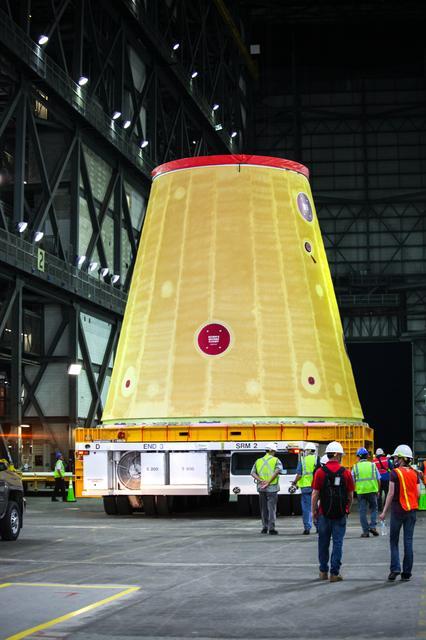
The Big Build: Artemis I Stacks Up
Our Space Launch System (SLS) rocket is coming together at the agency’s Kennedy Space Center in Florida this summer. Our mighty SLS rocket is set to power the Artemis I mission to send our Orion spacecraft around the Moon. But, before it heads to the Moon, NASA puts it together right here on Earth.

Read on for more on how our Moon rocket for Artemis I will come together this summer:
Get the Base

How do crews assemble a rocket and spacecraft as tall as a skyscraper? The process all starts inside the iconic Vehicle Assembly Building at Kennedy with the mobile launcher. Recognized as a Florida Space Coast landmark, the Vehicle Assembly Building, or VAB, houses special cranes, lifts, and equipment to move and connect the spaceflight hardware together. Orion and all five of the major parts of the Artemis I rocket are already at Kennedy in preparation for launch. Inside the VAB, teams carefully stack and connect the elements to the mobile launcher, which serves as a platform for assembly and, later, for fueling and launching the rocket.
Start with the boosters

Because they carry the entire weight of the rocket and spacecraft, the twin solid rocket boosters for our SLS rocket are the first elements to be stacked on the mobile launcher inside the VAB. Crews with NASA’s Exploration Ground Systems and contractor Jacobs team completed stacking the boosters in March. Each taller than the Statue of Liberty and adorned with the iconic NASA “worm” logo, the five-segment boosters flank either side of the rocket’s core stage and upper stage. At launch, each booster produces more than 3.6 million pounds of thrust in just two minutes to quickly lift the rocket and spacecraft off the pad and to space.
Bring in the core stage

In between the twin solid rocket boosters is the core stage. The stage has two huge liquid propellant tanks, computers that control the rocket’s flight, and four RS-25 engines. Weighing more than 188,000 pounds without fuel and standing 212 feet, the core stage is the largest element of the SLS rocket. To place the core stage in between the two boosters, teams will use a heavy-lift crane to raise and lower the stage into place on the mobile launcher.
On launch day, the core stage’s RS-25 engines produce more than 2 million pounds of thrust and ignite just before the boosters. Together, the boosters and engines produce 8.8 million pounds of thrust to send the SLS and Orion into orbit.
Add the Launch Vehicle Stage Adapter
Once the boosters and core stage are secured, teams add the launch vehicle stage adapter, or LVSA, to the stack. The LVSA is a cone-shaped element that connects the rocket’s core stage and Interim Cryogenic Propulsion Stage (ICPS), or upper stage. The roughly 30-foot LVSA houses and protects the RL10 engine that powers the ICPS. Once teams bolt the LVSA into place on top of the rocket, the diameter of SLS will officially change from a wide base to a more narrow point — much like a change in the shape of a pencil from eraser to point.
Lower the Interim Cryogenic Propulsion Stage into place

Next in the stacking line-up is the Interim Cryogenic Propulsion Stage or ICPS. Like the LVSA, crews will lift and bolt the ICPS into place. To help power our deep space missions and goals, our SLS rocket delivers propulsion in phases. At liftoff, the core stage and solid rocket boosters will propel Artemis I off the launch pad. Once in orbit, the ICPS and its single RL10 engine will provide nearly 25,000 pounds of thrust to send our Orion spacecraft on a precise trajectory to the Moon.
Nearly there with the Orion stage adapter

When the Orion stage adapter crowns the top of the ICPS, you’ll know we’re nearly complete with stacking SLS rocket for Artemis I. The Orion Stage Adapter is more than just a connection point. At five feet in height, the Orion stage adapter may be small, but it holds and carries several small satellites called CubeSats. After Orion separates from the SLS rocket and heads to the Moon, these shoebox-sized payloads are released into space for their own missions to conduct science and technology research vital to deep space exploration. Compared to the rest of the rocket and spacecraft, the Orion stage adapter is the smallest SLS component that’s stacked for Artemis I.
Top it off

Finally, our Orion spacecraft will be placed on top of our Moon rocket inside the VAB. The final piece will be easy to spot as teams recently added the bright red NASA “worm” logotype to the outside of the spacecraft. The Orion spacecraft is much more than just a capsule built to carry crew. It has a launch abort system, which will carry the crew to safety in case of an emergency, and a service module developed by the European Space Agency that will power and propel the spacecraft during its three-week mission. On the uncrewed Artemis I mission, Orion will check out the spacecraft’s critical systems, including navigation, communications systems, and the heat shield needed to support astronauts who will fly on Artemis II and beyond.
Ready for launch!

The path to the pad requires many steps and check lists. Before Artemis I rolls to the launch pad, teams will finalize outfitting and other important assembly work inside the VAB. Once assembled, the integrated SLS rocket and Orion will undergo several final tests and checkouts in the VAB and on the launch pad before it’s readied for launch.
The Artemis I mission is the first in a series of increasingly complex missions that will pave the way for landing the first woman and the first person of color on the Moon. The Space Launch System is the only rocket that can send NASA astronauts aboard NASA’s Orion spacecraft and supplies to the Moon in a single mission.
Make sure to follow us on Tumblr for your regular dose of space!
June 10 Solar Eclipse in the Northern Hemisphere!
On June 10, people in parts of the northern hemisphere will have the chance to witness a solar eclipse.

Watch the full visualization of the eclipse.
The June 10 eclipse is an annular solar eclipse, meaning that the Sun will never be completely covered by the Moon. The Moon’s orbit around the Earth is not a perfect circle, so throughout each month, the Moon’s distance from Earth varies. During an annular eclipse, the Moon is far enough away from Earth that the Moon appears smaller than the Sun in the sky. Since the Moon does not block the entire view of the Sun, it will look like a dark disk on top of a larger, bright disk. This creates what looks like a ring of fire around the Moon.
People in the narrow path of annularity — which, for this eclipse, cuts through Canada, Greenland, and northern Russia — will see the ring of fire effect as the Moon passes across the Sun.

Credit: Dale Cruikshank
Outside this path of annularity, many people in the northern hemisphere have a chance to see a partial solar eclipse. The partial eclipse will fall on parts of the eastern United States, as well as northern Alaska. Some locations will only see a very small piece of the Sun covered, while locations closer to the path of annularity can see the Moon cover most of the Sun.
To learn which times the eclipse may be visible in certain areas, you can click anywhere on the map here. (Note that the maximum obscuration and maximum eclipse timing noted on this map may occur before sunrise in many locations.)

This solar eclipse is a pair with the total lunar eclipse that happened on May 26.
Both solar and lunar eclipses happen when the Sun, Moon, and Earth line up in the same plane — a lunar eclipse happens when Earth is in the middle and casts its shadow on the Moon, and a solar eclipse happens when the Moon is in the middle and casts its shadow on Earth. The Moon’s orbit is tilted, so it’s usually too high or too low for this alignment to work out.

The May 26 lunar eclipse was a supermoon lunar eclipse, meaning that the full moon happened while the Moon was near its closest point to Earth, making the Moon appear larger in the sky. The solar eclipse happens at the opposite point of the Moon’s orbit, during the new moon — and in this case, the new moon happens near the Moon’s farthest point from Earth, making the Moon appear smaller and resulting in an annular (rather than total) solar eclipse.
How to watch the eclipse
From anywhere: Watch the eclipse online with us! Weather permitting, we’ll be sharing live telescope views of the partial eclipse courtesy of Luc Boulard of the Royal Astronomical Society of Canada Sudbury Centre. Tune in starting at 5 a.m. EDT on June 10 at nasa.gov/live.
From the path of the annular or partial eclipse: Be sure to take safety precuations if you plan to watch in person!
It is never safe to look directly at the Sun's rays, even if the Sun is partly or mostly obscured, like during a partial or annular eclipse — doing so can severely harm your eyes. If you’re planning to watch the eclipse on June 10, you should use solar viewing glasses or an indirect viewing method at all points during the eclipse if you want to face the Sun. Solar viewing glasses, sometimes called eclipse glasses, are NOT regular sunglasses; regular sunglasses are not safe for viewing the Sun.

If you don’t have solar viewing or eclipse glasses, you can use an alternate indirect method like a pinhole projector. Pinhole projectors shouldn’t be used to look at the Sun; instead, they’re an easy way to project an image of the Sun onto a surface. Read more about how to create a pinhole projector.
This is a sunrise eclipse in the contiguous U.S. At locations in the lower 48 states that can see the partial eclipse, the show starts before sunrise, when the Sun is still below the horizon. That means the best chance to see the eclipse in these locations will be during and shortly after sunrise, when the Sun is very low in the sky. In northern Alaska, the eclipse happens in the very early hours of June 10 when the Sun is low on the horizon.
Bottom line: If you’re trying to watch the eclipse in the contiguous U.S., look for a location with a clear view of the horizon to the northeast, and plan to watch starting at sunrise with your solar filter or indirect viewer.
The next two eclipses in the continental U.S. are in 2023 and 2024. The annular solar eclipse of Oct. 14, 2023, will cut from Oregon to Texas, and the total solar eclipse of April 8, 2024, will pass from Texas to Maine. Keep up with the latest on eclipses and eclipse science at nasa.gov/eclipse.
Make sure to follow us on Tumblr for your regular dose of space: http://nasa.tumblr.com.
That’s a wrap! Thank you for all the fantastic questions!
Recent University of Idaho graduate Hannah Johnson and NASA’s STEM on Station activity Manager Becky Kamas answered your questions about our Student Payload Opportunity with Citizen Science (SPOCS).
Checkout their full Answer Time.
SPOCS helps fund student experiments and launches them to the International Space Station to conduct research. Learn more about SPOCS and this year’s student teams building experiments for space HERE.
If today’s Answer Time got you fired up, HERE are other ways you can get involved with NASA as a student. We have contests, challenges, internships, games, and more!
Make sure to follow us on Tumblr for your regular dose of space: http://nasa.tumblr.com.
Questions coming up from….
@monicagellar: Is it open for international students?
@Anonymous: How should high school students get involved?
@Anonymous: Can I apply if my subjects are physics and chemistry in college
@unsuspicious-nobody: Do you have plans to repeat this/do something similar for students in the future?
Why are bacteria resistant polymers being experimented, specifically in microgravity?
What sparked your interest in science?
How are decisions made about what experiments are sent into space? Are there certain kinds of experiments that NASA wants to conduct every time cargo is launched to the ISS, or are there occasionally experiments that are duplicated for more observation and data collection?